
Оставить заявку
Для заказа и получения более подробной информации оставьте заявку, наш менеджер свяжется с Вами!
Нажимая на кнопку, вы даете согласие на обработку персональных данных и соглашаетесь c политикой конфиденциальности
Постоянно-рассеивающая интерферометрия: обзор
Микеле Крозетто a,∗a,∗ , Ориоль Монсеррат aa , Мария Куэвас-Гонсалес aa , Нурия Девантери aa , Бруно Криппа bb
aa Centre Tecnológico de Telecomunicaciones de Catalunya (CTTC), Division of Geomatics, Av. Gauss 7, E- 08860 Castelldefels, Барселона, Испания
bb Department of Earth Sciences, University of Milan, Via Cicognara 7, I- 20129 Милан, Италия
ИНФОРМАЦИЯ О СТАТЬЕ
АННОТАЦИЯ
История статьи:
Получена 13 мая 2015 г.
Получена в переработанном виде 26 октября 2015 г.
Принята 28 октября 2015 г.
Доступна онлайн 19 ноября 2015 г.
Ключевые слова:
Дистанционное зондирование
Радиолокация
SAR
Мониторинг
Деформация
Постоянно-рассеивающая интерферометрия (PSI) — это мощный метод дистанционного зондирования, позволяющий измерять и отслеживать смещения земной поверхности с течением времени. В частности, PSI — это радиолокационная методика, относящаяся к группе дифференциальной интерферометрической радиолокации с синтезированной апертурой (SAR). В данной статье представлен обзор метода PSI. Сначала напоминаются основные принципы интерферометрии SAR, дифференциальной интерферометрии SAR и PSI. Затем приводится обзор основных алгоритмов PSI, предложенных в литературе, с описанием главных подходов и наиболее важных работ, посвящённых отдельным аспектам PSI. Центральная часть статьи посвящена обсуждению различных характеристик и технических аспектов PSI, например, доступности данных SAR, максимальных скоростей деформации, временных рядов деформации, компоненты теплового расширения в наблюдениях PSI и т.д. Далее рассматриваются наиболее важные мероприятия по валидации PSI, которые дали ценные сведения для развития PSI и её признания на научном, техническом и коммерческом уровне. За этим следует описание основных приложений PSI, разработанных за последние пятнадцать лет. Статья завершается обсуждением основных открытых проблем PSI и соответствующих направлений будущих исследований.
®R◯ 2015 Авторы. Опубликовано Elsevier B.V. от имени Международного общества фотограмметрии и дистанционного зондирования (ISPRS). Это статья открытого доступа по лицензии CC BY-NC-ND (http://creativecommons.org/licenses/by-nc-nd/4.0/).
1. Введение
В данной статье предлагается обзор постоянно-рассеивающей интерферометрии (PSI) — мощного метода дистанционного зондирования, позволяющего измерять смещения земной поверхности. В этой работе термины «смещение» и «деформация» используются как взаимозаменяемые. Как будет описано более подробно ниже, PSI представляет собой конкретный класс методов дифференциальной интерферометрической радиолокации с синтезированной апертурой (DInSAR). Такие методы используют информацию, содержащуюся в радиолокационной фазе, по крайней мере, двух комплексных SAR-изображений, полученных в разное время над одной и той же областью, которые используются для формирования интерферометрической пары. Повторное получение изображений над заданной областью обычно выполняется с помощью одного и того же сенсора или сенсоров с идентичными системными характеристиками. Габриэль и др. (1989) дали первое описание DInSAR, основанное на данных L-диапазона спутника Seasat. Общий обзор интерферометрии SAR см. в работах Бамлера и Хартля (1998) и Розена и др. (2000).
Принцип DInSAR кратко изложен ниже. Рассматривая отдельный пиксель на местности P, сенсор получает первое SAR-изображение из позиции спутника M, измеряя фазу ϕMϕM:
ϕM=ϕgeom−M+ϕscatt−M=λ4⋅π⋅MP+ϕscatt−M(1)
где MP — расстояние от сенсора до цели, ϕscattϕscatt — фазовый сдвиг, возникающий при взаимодействии микроволн с целью P, λλ — длина волны радара, а коэффициент 4π4π связан с двусторонним проходом сигнала «радар-цель-радар». Предполагая, что сенсор получает второе изображение из позиции спутника S, измеряя фазу ϕSϕS над тем же пикселем P, тогда:
ϕS=ϕgeom−S+ϕscatt−S=λ4⋅π⋅SP+ϕscatt−S(2)
Метод интерферометрической SAR (InSAR) использует разность фаз ϕS−ϕMϕS−ϕM:
Δϕint=ϕS−ϕM=4πλSP−MP+ϕscatt−S−ϕscatt−M(3)
Эта фаза называется интерферометрической фазой и связана с разностью расстояний SP−MPSP−MP, что имеет фундаментальное значение для создания цифровых моделей рельефа (ЦМР), т.е. для оценки топографии наблюдаемой сцены, см. Бамлер и Хартль (1998) и Розен и др. (2000). Чувствительность InSAR к топографии зависит от базовой линии спутника SM и, более конкретно, от проекции SM на направление, перпендикулярное линии визирования (LOS) SAR, называемой перпендикулярной базовой линией.
В случае измерения деформации DInSAR, рассматривая отдельный пиксель P и первое получение из позиции спутника M (см. Рис. 1), измеряется фаза ϕMϕM, см. уравнение (1). Затем, предполагая, что цель перемещается из P в P' и после этого сенсор получает второе изображение из позиции спутника S, оценивается ϕSϕS:
ϕS=ϕgeom−S+ϕscatt−S=λ4⋅π⋅SP′+ϕscatt−S(4)
В этом случае интерферометрическая фаза ΔϕintΔϕint определяется как:
Δϕint=ϕS−ϕM=4πλSP′−MP+ϕscatt−S−ϕscatt−M(5)
Путем добавления и вычитания члена SP/(λ4π)SP/(4πλ) получается следующее уравнение:
Δϕint=ϕS−ϕM=4πλSP−MP+4πλSP′−SP+ϕscatt−S−ϕscatt−M(6)
где первый член представляет собой топографическую фазовую компоненту ϕTopoϕTopo, которая включает так называемую опорную эллипсоидальную фазовую компоненту, а второй член — фазовую компоненту смещения ϕDispϕDisp, связанную со смещением вдоль LOS d, показанным на Рис. 1. Предполагая, что последние два члена уравнения (6) сокращаются, если доступна ЦМР наблюдаемой сцены, ϕTopoϕTopo может быть смоделирована и вычтена из ΔϕintΔϕint (это операция, обратная созданию ЦМР в InSAR), получая так называемую DInSAR-фазу ΔϕD−intΔϕD−int:
ΔϕD−int=Δϕint−ϕTopo_simu=ϕDisp(7)
где ϕTopo_simuϕTopo_simu — смоделированная топографическая компонента, которая неявно содержит компоненту плоской Земли. Обратите внимание, что ошибки орбиты влияют на эту смоделированную топографическую компоненту, даже если процесс исключения влияния плоской Земли не выполняется явно. Уравнение (7) резюмирует
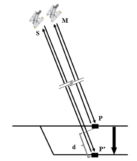
Рис. 1. Схема измерения деформации в DInSAR.
принцип работы DInSAR, который позволяет получать смещения наблюдаемой сцены из двух комплексных SAR-изображений. Этот принцип широко использовался в течение последних 25 лет, дав значительные результаты в области сейсмологии (Массоне и др., 1993; Пельцер и Розен, 1995; Далла Виа и др., 2012), вулканологии (Массоне и др., 1995; Массоне и Сигмундссон, 2000; Антониели и др., 2014), гляциологии (Гольдштейн и др., 1993; Риньо и др., 1997), оползнях (Карнек и др., 1996; Гарсия-Давальо и др., 2014), просадках и поднятиях грунта (Галлоуэй и др., 1998; Амелунг и др., 1999) и т.д. Подробные обзоры различных применений DInSAR представлены Массоне и Фейглем (1998) и Ханссеном (2001).
Уравнение (7) представляет собой упрощенное уравнение наблюдений DInSAR. Полное уравнение включает:
ΔϕD−int=Δϕint−ϕTopo_simu=ϕDisp+ϕTopo_res+ϕAtm_S−ϕAtm_M+ϕorb_S−ϕorb_M+ϕNoise+2⋅k⋅π(8)
где ϕTopo_resϕTopo_res — компонента остаточной топографической ошибки (RTE), ϕAtmϕAtm — атмосферная фазовая компонента в момент получения каждого изображения, ϕorbϕorb — фазовая компонента, обусловленная орбитальными ошибками каждого изображения (ошибками, влияющими на положение M и S на Рис. 1), а ϕNoiseϕNoise — фазовый шум. Последний член 2⋅k⋅π2⋅k⋅π, где kk — целое число, называемое фазовой неоднозначностью, является результатом свёрнутого (wrapped) характера ΔϕD−intΔϕD−int, т.е. того факта, что DInSAR-фазы ограничены диапазоном (−π,π](−π,π].
Цель любого метода DInSAR — извлечь ϕDispϕDisp из ΔϕD−intΔϕD−int. Это подразумевает отделение ϕDispϕDisp от других фазовых компонент уравнения (8). Необходимым условием для выполнения этого разделения является анализ пикселей, характеризующихся малым ϕNoiseϕNoise, которые обычно связаны с двумя типами отражателей: теми, где отклик на радар доминирует от сильного отражающего объекта и постоянен во времени (постоянный рассеиватель, PS), и теми, где отклик постоянен во времени, но обусловлен различными мелкими рассеивающими объектами (распределённые рассеиватели, DS). Основные ограничения DInSAR включают: (i) временную и геометрическую декорреляции, влияющие на компоненту ϕNoiseϕNoise (Ханссен, 2001); (ii) развёртку фазы (phase unwrapping), касающуюся оценки kk (Гилья и Притт, 1998); и (iii) атмосферную компоненту (Зебкер и др., 1997). Методы суммирования (stacking) DInSAR (Зебкер и др., 1997; Сандвелл и Прайс, 1998; Райт и др., 2001) включают различные подходы для уменьшения атмосферных эффектов путём усреднения нескольких интерферограмм.
PSI представляет собой конкретный класс методов DInSAR, использующих множество SAR-изображений, полученных над одной и той же областью, и соответствующие процедуры обработки и анализа данных для отделения ϕDispϕDisp от других фазовых компонент, представленных в уравнении (8). Термин PSI используется в этой работе для обозначения ряда различных методов, включая подход с постоянными рассеивателями (первая методика PSI, предложенная Ферретти и др. (2000, 2001)), другие методы, основанные на PS, методы, основанные на DS, и другие гибридные методы. Другие авторы называют PSI такими терминами, как интерферометрия временных рядов (ван Лейен, 2014), передовая DInSAR (Эррера и др., 2007) и т.д. Основные результаты PSI-анализа включают временные ряды деформации и скорость деформации, оценённые для анализируемых PS или DS, см. пример на Рис. 2. В дальнейшем термин PS будет включать как PS, так и DS. Другим результатом PSI-анализа является так называемая остаточная топографическая ошибка (RTE), представляющая собой разницу между истинной высотой фазового центра рассеяния данного PS и высотой ЦМР в этой точке. RTE является ключевым параметром для достижения точной геокодировки PS.
Данный обзор не рассматривает SAR-томографию (Рейгбер и Морейра, 2000; Ломбардини, 2005) и наземную интерферометрию SAR (Монсеррат и др., 2014) и организован следующим образом:
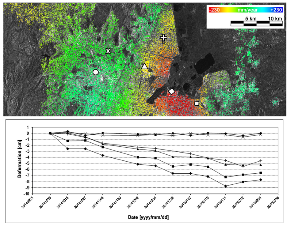
Рис. 2. Пример результатов PSI: скорости деформации вдоль LOS (слева) и временные ряды для выбранных PS (справа).
основные алгоритмы PSI, предложенные в литературе, рассматриваются в Разделе 2; несколько технических аспектов методов PSI обсуждаются в Разделе 3; валидация результатов PSI описывается в Разделе 4; основные применения PSI рассматриваются в Разделе 5; и, наконец, в Разделе 6 обсуждаются основные открытые проблемы PSI и соответствующие направления будущих исследований.
2. Алгоритмы PSI
В этом разделе обсуждаются основные алгоритмы PSI, предложенные в литературе. Подходы PSI сначала описываются в хронологическом порядке. Некоторые из их ключевых характеристик суммированы в Таблице 1. Затем подробно описываются и обсуждаются четыре наиболее важных подхода PSI. После этого следует краткий обзор наиболее важных работ, посвящённых отдельным аспектам PSI.
Первая методика PSI — это подход с постоянными рассеивателями, предложенный Ферретти и др. (2000, 2001). Этим двум публикациям предшествовал патент на алгоритм PSInSAR и основание дочерней компании Политехнического университета Милана под названием Tele-Rilevamento Europa, TRE (www.treuropa.com). За этими двумя новаторскими работами последовало несколько других вкладов. Техника Small BAseline Subset (SBAS) (Берардино и др., 2002) является одной из наиболее широко используемых. Обзор алгоритма SBAS представлен Ланари и др. (2007a). Подобные SBAS подходы, основанные на мультивью-изображениях, были предложены Мора и др. (2003) и Шмидтом и Бюргманном (2003). В том же году две компании, специализирующиеся на PSI, Gamma Remote Sensing (www.gamma-rs.ch) и Altamira Information (www.altamira-information.com), описали свои подходы в работах Вернера и др. (2003) и Дуро и др. (2003) соответственно. Кампес и Ханссен (2004) адаптировали метод LAMBDA, используемый в GPS, для PSI, который затем был включён в сеть пространственно-временной развёртки STUN, описанную в Кампесе (2006). Хупер и др. (2004) описали процедуру PSI, предназначенную для анализа эпизодической коровой деформации в негородских условиях. Крозетто и др. (2005) описали упрощённый подход PSI, основанный на кусочно-линейных функциях деформации и методе наименьших квадратов. Костантини и др. (2008), см. также Костантини и др. (2014), предложили метод PSI, который использует только относительные свойства соседних пар PS. Лопес-Кирос и др. (2009) представили новый алгоритм SBAS, основанный на параметризованной во времени инверсии. Ферретти и др. (2011) предложили расширение алгоритма PSInSAR, названное алгоритмом SqueeSAR. Периссин и Ван (2012) представили подход PSI для использования частично когерентных целей. Алгоритм, основанный на вейвлет-разложении в пространстве и общей параметризации во времени, был предложен Хетландом и др. (2012). Алгоритм PSI, основанный на геодезической теории оценивания, был предложен ван Лейеном (2014). Гоэль и Адам (2014) описали подход PSI для мониторинга известных
Таблица 1
Характеристики основных подходов PSI.
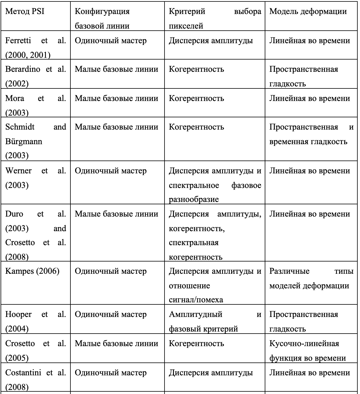
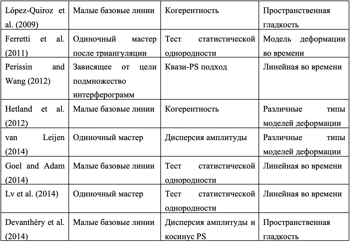
поверхностных деформационных явлений, т.е. явлений, характер деформации которых известен. Подход PSI, использующий информацию о когерентности стеков соседних пикселей, был предложен Лю и др. (2014). Наконец, Девантери и др. (2014) предложили подход PSI, основанный на так называемых «кузенных PS» (Cousin PSs), который включает алгоритм 2+1D развёртки фазы. Основные характеристики упомянутых подходов PSI суммированы в Таблице 1. Для каждого подхода приведены конфигурация базовой линии, критерий выбора пикселей и используемая модель деформации. Подробный обзор нескольких методов PSI см. в работе ван Лейена (2014).
Ниже кратко обсуждаются четыре наиболее важных подхода с точки зрения их влияния на область PSI. Методика PSInSAR, предложенная Ферретти и др. (2000, 2001), безусловно, является самой важной, поскольку она представляла собой первое полное решение для выбора PS, преодоления временной и геометрической декорреляции, а также оценки деформации и RTE, отделяя их от вклада APS. Это стало значительным шагом вперёд по сравнению с существовавшими ранее методами DInSAR, что резко повысило их применимость, и эта работа стала основой для дальнейшего развития. Основным ограничением этого подхода является то, что он ограничен рассеивателями, демонстрирующими достаточно высокую когерентность даже при больших базовых линиях, что обычно приводит к низкой плотности PS в негородских районах. Методика SBAS (Берардино и др., 2002) представляет собой ещё одну новаторскую работу, предлагающую полную процедуру PSI, использующую малые базовые линии для ограничения пространственной декорреляции, мультивью-данные для уменьшения фазового шума и критерий выбора на основе когерентности. Кроме того, в ней используется подход для связывания нескольких подмножеств малых базовых линий. Это приводит к увеличению пространственного и временного разрешения по сравнению с исходным подходом PSInSAR. Первоначальная SBAS работает с мультивью-изображениями и не подходит для обнаружения локальной деформации. Этот аспект был решён в расширенной версии SBAS, работающей с полноразрешающими данными (Ланари и др., 2004a). Ещё один важный вклад в PSI был сделан Хупером и др. (2004). Они предложили новый выбор PS с использованием фазовых характеристик, который подходит для поиска малоамплитудных природных целей с фазовой стабильностью, которые не могут быть идентифицированы алгоритмами на основе амплитуды. Важным преимуществом является то, что он не требует априорной модели деформации. Эта работа послужила основой для одного из наиболее широко используемых пакетов программного обеспечения PSI, StaMPS (Хупер и Зебкер, 2007; Хупер, 2008). Наконец, крупный шаг вперёд в PSI связан с алгоритмом SqueeSAR, предложенным Ферретти и др. (2011). Они расширили алгоритм PSInSAR, совместно обрабатывая PS и DS, учитывая их статистическое поведение. Алгоритм SqueeSAR ориентирован на пиксели, принадлежащие областям умеренной когерентности, где соседние пиксели имеют одинаковые значения отражательной способности, поскольку они принадлежат одному объекту. Результатом SqueeSAR является улучшенная плотность и качество результатов PSI, что особенно заметно в негородских районах. Другие подходы были разработаны на основе аналогичных методов, например, см. Гоэль и Адам (2014) и Лю и др. (2014).
Несколько работ были посвящены отдельным аспектам PSI, и здесь упоминается выборка наиболее важных из них. Периссин и Ферретти (2007) и Динатаялан и др. (2011) изучали физическую природу SAR PS, предложив метод их идентификации и характеристики. ван Лейен и Ханссен (2007) описали использование адаптивных моделей деформации для увеличения плотности PS. Колесанти и др. (2003) предложили расширение PSInSAR для мониторинга сезонных деформационных явлений грунта. Подобный подход затем использовался для моделирования смещений, вызванных тепловым расширением, например, см. Гернхардт и др. (2010). Более точная модель теплового расширения описана в Монсеррате и др. (2011). Развёртка фазы является одним из наиболее критических этапов обработки в методах PSI. Важной темой, затронутой несколькими авторами, является использование 3D пространственно-временной природы развёртки фаз стеков интерферограмм, например, см. Костантини и др. (2002), Пепе и Ланари (2006), Хупер и Зебкер (2007), Пепе и др. (2011), Форнаро и др. (2011) и Девантери и др. (2014). В целом, 3D подходы к развёртке фазы обеспечивают результаты лучшего качества по сравнению с 2D подходами, выполняемыми для каждой интерферограммы отдельно.
Оценка атмосферной фазовой компоненты по наблюдениям PSI является ещё одним ключевым аспектом исследований PSI, и Ханссен (2001) представляет подробный анализ этой компоненты. Были предложены различные методы коррекции этой атмосферной компоненты, включая некоторые, использующие наблюдения ГНСС или данные численных моделей погоды, см. Лейтон (2010), Каталао и др. (2011), Лю (2012), Юнг и др. (2014), Форнаро и др. (2014), Альшаваф и др. (2015) и т.д.
Несколько работ были посвящены поляриметрической PSI, целью которой является максимизация качества и количества выбранных PS, обеспечивая их надёжность a priori путём оптимизации параметров, используемых в качестве критерия отбора, см. Самсонов и Тиампо (2011), Наварро-Санчес и Лопес-Санчес (2012, 2014), Наварро-Санчес и др. (2014). Адам и др. (2011, 2013) описали технические сложности и алгоритмические решения, необходимые для расширения PSI-картирования от городских районов, где PSI обычно показывает хорошие результаты, до сельских и горных регионов, охватывая таким образом обширные территории. Другие работы, связанные с PSI на больших территориях, включают Каро Куэнка и др. (2011) и Костантини и др. (2012). Хотя большинство результатов PSI, опубликованных в литературе, были получены с использованием SAR-данных, полученных в режиме StripMap, несколько авторов рассмотрели потенциал различных режимов съёмки для интерферометрии SAR и PSI. Различия между интерферометрической обработкой данных StripMap и Spotlight SAR описаны в Эйнедер и др. (2009), а различные работы были посвящены изучению характеристик данных TOPS SAR, получаемых Sentinel-1 (Торрес и др., 2012; Руччи и др., 2012). Большинство этих работ были сосредоточены на корегистрации TOPS-изображений, которая представляет собой наиболее критическую проблему с интерферометрической точки зрения, см. Де Зан и Монти Гуарньери (2006) и Пратс-Ираола и др. (2012). В заключение стоит упомянуть, что существует несколько инструментов для анализа DInSAR и PSI с открытым исходным кодом, см. Кампес и др. (2003), Розен и др. (2004, 2001), Хупер (2008), Сандвелл и др. (2011) и Аграм и др. (2013). Кроме того, Периссин и др. (2011) описали программное обеспечение, которое, хотя и не является открытым, доступно для совместных проектов.
Ниже кратко обсуждаются четыре наиболее важных подхода с точки зрения их влияния на область PSI. Методика PSInSAR, предложенная Ферретти и др. (2000, 2001), безусловно, является самой важной, поскольку она представляла собой первое полное решение для выбора PS, преодоления временной и геометрической декорреляции, а также оценки деформации и RTE, отделяя их от вклада APS. Это стало значительным шагом вперёд по сравнению с существовавшими ранее методами DInSAR, что резко повысило их применимость, и эта работа стала основой для дальнейшего развития. Основным ограничением этого подхода является то, что он ограничен рассеивателями, демонстрирующими достаточно высокую когерентность даже при больших базовых линиях, что обычно приводит к низкой плотности PS в негородских районах. Методика SBAS (Берардино и др., 2002) представляет собой ещё одну новаторскую работу, предлагающую полную процедуру PSI, использующую малые базовые линии для ограничения пространственной декорреляции, мультивью-данные для уменьшения фазового шума и критерий выбора на основе когерентности. Кроме того, в ней используется подход для связывания нескольких подмножеств малых базовых линий. Это приводит к увеличению пространственного и временного разрешения по сравнению с исходным подходом PSInSAR. Первоначальная SBAS работает с мультивью-изображениями и не подходит для обнаружения локальной деформации. Этот аспект был решён в расширенной версии SBAS, работающей с полноразрешающими данными (Ланари и др., 2004a). Ещё один важный вклад в PSI был сделан Хупером и др. (2004). Они предложили новый выбор PS с использованием фазовых характеристик, который подходит для поиска малоамплитудных природных целей с фазовой стабильностью, которые не могут быть идентифицированы алгоритмами на основе амплитуды. Важным преимуществом является то, что он не требует априорной модели деформации. Эта работа послужила основой для одного из наиболее широко используемых пакетов программного обеспечения PSI, StaMPS (Хупер и Зебкер, 2007; Хупер, 2008). Наконец, крупный шаг вперёд в PSI связан с алгоритмом SqueeSAR, предложенным Ферретти и др. (2011). Они расширили алгоритм PSInSAR, совместно обрабатывая PS и DS, учитывая их статистическое поведение. Алгоритм SqueeSAR ориентирован на пиксели, принадлежащие областям умеренной когерентности, где соседние пиксели имеют одинаковые значения отражательной способности, поскольку они принадлежат одному объекту. Результатом SqueeSAR является улучшенная плотность и качество результатов PSI, что особенно заметно в негородских районах. Другие подходы были разработаны на основе аналогичных методов, например, см. Гоэль и Адам (2014) и Лю и др. (2014).
Несколько работ были посвящены отдельным аспектам PSI, и здесь упоминается выборка наиболее важных из них. Периссин и Ферретти (2007) и Динатаялан и др. (2011) изучали физическую природу SAR PS, предложив метод их идентификации и характеристики. ван Лейен и Ханссен (2007) описали использование адаптивных моделей деформации для увеличения плотности PS. Колесанти и др. (2003) предложили расширение PSInSAR для мониторинга сезонных деформационных явлений грунта. Подобный подход затем использовался для моделирования смещений, вызванных тепловым расширением, например, см. Гернхардт и др. (2010). Более точная модель теплового расширения описана в Монсеррате и др. (2011). Развёртка фазы является одним из наиболее критических этапов обработки в методах PSI. Важной темой, затронутой несколькими авторами, является использование 3D пространственно-временной природы развёртки фаз стеков интерферограмм, например, см. Костантини и др. (2002), Пепе и Ланари (2006), Хупер и Зебкер (2007), Пепе и др. (2011), Форнаро и др. (2011) и Девантери и др. (2014). В целом, 3D подходы к развёртке фазы обеспечивают результаты лучшего качества по сравнению с 2D подходами, выполняемыми для каждой интерферограммы отдельно.
Оценка атмосферной фазовой компоненты по наблюдениям PSI является ещё одним ключевым аспектом исследований PSI, и Ханссен (2001) представляет подробный анализ этой компоненты. Были предложены различные методы коррекции этой атмосферной компоненты, включая некоторые, использующие наблюдения ГНСС или данные численных моделей погоды, см. Лейтон (2010), Каталао и др. (2011), Лю (2012), Юнг и др. (2014), Форнаро и др. (2014), Альшаваф и др. (2015) и т.д.
Несколько работ были посвящены поляриметрической PSI, целью которой является максимизация качества и количества выбранных PS, обеспечивая их надёжность a priori путём оптимизации параметров, используемых в качестве критерия отбора, см. Самсонов и Тиампо (2011), Наварро-Санчес и Лопес-Санчес (2012, 2014), Наварро-Санчес и др. (2014). Адам и др. (2011, 2013) описали технические сложности и алгоритмические решения, необходимые для расширения PSI-картирования от городских районов, где PSI обычно показывает хорошие результаты, до сельских и горных регионов, охватывая таким образом обширные территории. Другие работы, связанные с PSI на больших территориях, включают Каро Куэнка и др. (2011) и Костантини и др. (2012). Хотя большинство результатов PSI, опубликованных в литературе, были получены с использованием SAR-данных, полученных в режиме StripMap, несколько авторов рассмотрели потенциал различных режимов съёмки для интерферометрии SAR и PSI. Различия между интерферометрической обработкой данных StripMap и Spotlight SAR описаны в Эйнедер и др. (2009), а различные работы были посвящены изучению характеристик данных TOPS SAR, получаемых Sentinel-1 (Торрес и др., 2012; Руччи и др., 2012). Большинство этих работ были сосредоточены на корегистрации TOPS-изображений, которая представляет собой наиболее критическую проблему с интерферометрической точки зрения, см. Де Зан и Монти Гуарньери (2006) и Пратс-Ираола и др. (2012). В заключение стоит упомянуть, что существует несколько инструментов для анализа DInSAR и PSI с открытым исходным кодом, см. Кампес и др. (2003), Розен и др. (2004, 2001), Хупер (2008), Сандвелл и др. (2011) и Аграм и др. (2013). Кроме того, Периссин и др. (2011) описали программное обеспечение, которое, хотя и не является открытым, доступно для совместных проектов.
3. Технические вопросы
В этом разделе обсуждаются несколько характеристик и технических аспектов, которые особенно важны с точки зрения применения PSI.
3.1. Доступность данных SAR
Способность отслеживать деформационные явления во времени зависит от доступности данных SAR, которая, в свою очередь, зависит от наличия работающих SAR-сенсоров, времени повторного визита спутника SAR (время между интерферометрическими наблюдениями одной и той же области сенсором или сенсорами с идентичными характеристиками), политики получения данных, орбитальной трубки, т.е. допустимых перпендикулярных базовых линий (Рокка, 2004) и т.д. На момент написания этого обзора действует несколько SAR-миссий: созвездие CosmoSkyMed из четырёх спутников (X-диапазон), TerraSAR-X и TanDEM-X (X-диапазон), Sentinel-1 (C-диапазон), Radarsat-2 (C-диапазон) и ALOS-2 (L-диапазон). Однако политика получения данных этих миссий, например, фоновые миссии (регулярная съёмка заданных областей) по сравнению со съёмкой по запросу, влияет на доступность данных, которая крайне неравномерна по всему миру. PSI требует большого количества сцен SAR, полученных над одной и той же областью. Как правило, для выполнения C-диапазонного PSI-анализа требуется минимум 15-20 изображений. Можно использовать более короткие наборы данных с X-диапазонной PSI благодаря более высокому разрешению и меньшей длине волны этого диапазона (Бовенга и др., 2012). В любом случае, чем больше доступных сцен, тем лучше качество оценки скорости деформации и временных рядов PSI. Кроме того, это число критично для оцениваемости тех PSI-моделей, которые включают несколько неизвестных параметров, например, см. Монсеррат и др. (2011) и ван Лейен (2014).
3.2. Доступность PS
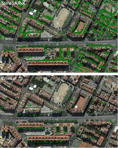
PSI — это оппортунистический метод измерения деформации, т.е. он способен измерять деформацию только по доступным PS. Плотность PS обычно низкая в заросших растительностью, лесных районах и районах с низкой отражательной способностью (например, очень гладкие поверхности), а также на крутых склонах, обращённых к радарам. Снежный покров, строительные работы, переасфальтирование улиц и т.д. могут привести к полной или частичной потере PS. Напротив, PS обычно многочисленны на зданиях, памятниках, антеннах, столбах, трубах, обнажённых скалах или выходах пород и т.д. Некоторые работы были посвящены использованию временных или частично когерентных PS, т.е. рассеивателей, которые ведут себя как PS только в течение части данного стека данных, например, см. Базилико и др. (2004), Чжан и др. (2011) и Периссин и Ван (2012). Использование таких PS значительно увеличивает измерения деформации. Как правило, местоположение PS не может быть известно до выполнения PSI-анализа. Это может быть критично для изучения областей и объектов малой пространственной протяжённости, поскольку они могут быть недооценены или даже не отобраны. Этот аспект частично смягчается использованием SAR-данных X-диапазона очень высокого разрешения (Крозетто и др., 2010). Сравнение плотности PS, достигаемой с помощью C-диапазонной и X-диапазонной PSI, показано на Рис. 3. Ключевым моментом PSI является сложность точного сопоставления данного PS с объектом или частью объекта, если только не используются уголковые отражатели. Это ограничивающий фактор, особенно для локализованных анализов деформации. Интересные работы по улучшению понимания и интерпретации PS — это Ауэр и др. (2010, 2011). В отношении интерпретации результатов PSI существует заметное различие между возможностями отбора проб деформации, достигаемыми с помощью PSI и геодезических методов съёмки. Последние используют стратегически расположенные точки, т.е. точки, выбранные специально для надлежащей выборки данного деформационного явления. Напротив, PSI выполняет оппортунистическую выборку, основанную на тех рассеивателях, которые обеспечивают стабильное радиолокационное отражение с течением времени. Поэтому связь между деформацией этих рассеивателей и интересующим деформационным явлением должна тщательно оцениваться в каждом конкретном случае.
3.3. Искусственные уголковые отражатели
Отсутствие PS или низкая плотность PS над заданной областью могут быть компенсированы установкой искусственных уголковых отражателей (CR). Эти устройства, установленные на месте, обеспечивают сильный отклик на SAR-изображениях, что даёт хорошие интерферометрические фазы для получения оценок деформации (Сарабанди и Чиу, 1996; Дорри, 2008). Используя CR, можно стратегически располагать точки измерения деформации, хотя этот подход требует доступа к интересующей области для установки CR и, таким образом, отклоняется от чисто спутникового дистанционного зондирования. CR могут быть установлены постоянно на месте. В этом случае их целостность должна быть гарантирована на протяжении всего периода мониторинга. Альтернативно, CR можно устанавливать и демонтировать при каждом получении изображения. Некоторые технические аспекты DInSAR-мониторинга с использованием CR описаны в Ся и др. (2002) и Крозетто и др. (2013). CR использовались в различных исследованиях для оценки эффективности DInSAR и PSI (Ферретти и др., 2007; Маринкович и др., 2007; Куин и Лоро, 2013). Они также использовались в нескольких приложениях PSI, например, см. ван Лейен и Ханссен (2007), Вегмюллер и др. (2010), Дацин и др. (2011), Театини и др. (2012) и Юй и др. (2013).
3.4. Максимальные скорости деформации и линейная модель деформации
PSI испытывает серьёзные ограничения в возможности измерения «быстрых» деформационных явлений из-за неоднозначного характера своих наблюдений, т.е. свёрнутых интерферометрических фаз. Рассматривая упрощённое уравнение (7) и вычисляя разность фаз между двумя PS, i и j:
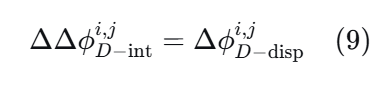
Ограничение, обусловленное неоднозначным характером наблюдения, является серьёзным. Фактически, когда дифференциальная DInSAR-фаза деформации ΔϕD−dispi,jΔϕD−dispi,j между двумя последовательными получениями больше ππ, реальную деформацию нельзя получить однозначно. Предел ππ для дифференциальных фаз соответствует максимальной дифференциальной деформации λ/4λ/4 за интервал повторного визита. С учётом их длины волны и времени повторного визита, максимальная измеряемая дифференциальная скорость деформации составляет 14.7, 25.7, 42.6 и 46.8 см/год46.8 см/год для Envisat, TerraSAR-X, Sentinel-1 и ALOS соответственно. Это теоретические значения; фактическая способность оценивать скорости деформации зависит от уровня шума данных и конкретной методики развёртки фазы, используемой для разрешения фазовых неоднозначностей (ван Лейен, 2014). Важно отметить, что вышеупомянутое условие касается дифференциальных фаз, т.е. фаз, вычисленных по парам PS. Фактическая способность измерять деформацию над данным PS зависит от пространственной структуры конкретного деформационного явления (чем глаже эта структура, тем лучше) и доступной плотности PS над этим явлением (чем выше плотность, тем лучше). Для всех явлений, деформация которых значительно превышает вышеупомянутый предел, можно дополнить измерения PSI методами, основанными на амплитуде SAR, например, см. Касу и др. (2011). Идея заключается в использовании амплитудной информации SAR по крайней мере двух SAR-изображений, полученных в разное время, путём оценки 2D смещений (пиксельных смещений) поперёк трека (дальность) и вдоль трека (азимут) заданных целей. Для этого требуются методы сопоставления изображений. Стоит отметить, что этот подход даёт 2D измерения деформации, на которые не влияет неоднозначный характер интерферометрических подходов. Его основным ограничением является низкая чувствительность к деформации, которая составляет долю пикселя SAR (например, 1/10 или 1/20 пикселя, см. Фиалко и др. (2001) и Строцци и др. (2002)) и зависит от локального контраста амплитуды SAR. Многие подходы PSI используют линейную модель деформации в своих процедурах оценки деформации, см. Таблицу 1. Например, продукты деформации PSI, созданные в проекте Terrafirma (http://www. terrafirma.eu.com), были основаны на этой модели. Это допущение, необходимое для развёртки интерферометрических фаз, может оказывать негативное влияние на оценки деформации всех явлений, характеризующихся нелинейным поведением деформации, где это допущение недействительно. Продукты PSI, основанные на линейном допущении, обычно не содержат PS во всех областях, где деформация показывает значительно нелинейное движение, из-за несоответствия между линейной моделью и наблюдаемой (нелинейной) деформацией. Обратите внимание, что это может быть критическим аспектом, поскольку он затрагивает области, где интерес к измерению деформации наиболее высок,
что представляет собой ограничение применимости PSI. Некоторые подходы PSI не используют линейную модель деформации, см. Таблицу 1, предполагая пространственную гладкость наблюдаемых деформационных явлений. Однако стоит подчеркнуть, что эти методы страдают от ограничения, связанного с неоднозначным характером фаз, которое описано выше.
3.5. Временные ряды деформации
Временные ряды деформации представляют собой наиболее совершенный продукт PSI. Они предоставляют историю деформации за наблюдаемый период, что имеет фундаментальное значение для многих приложений, например, изучения кинематики данного явления (покой, активация, ускорение и т.д.), корреляции с движущими факторами и т.д. Чтобы правильно использовать, интерпретировать и эксплуатировать временные ряды деформации, важно учитывать, что они являются продуктом с нулевой избыточностью. Фактически, они содержат одну оценку деформации на каждое получение SAR, т.е. на каждое наблюдение. По этой причине они особенно чувствительны к фазовому шуму. Этот аспект был подчёркнут в проекте валидации Terrafirma при анализе данных C-диапазона ERS и Envisat (Крозетто и др., 2008b). Временные ряды X-диапазона показывают заметное улучшение качества по сравнению с временными рядами C-диапазона, например, см. (Крозетто и др., 2010). Важно учитывать, что, если используется, линейная модель деформации может значительно доминировать над структурами временных рядов, и этот вопрос необходимо тщательно учитывать при интерпретации данных. Обратите внимание, что некоторые подходы PSI не используют никакой линейной модели деформации, см. Таблицу 1.
3.6. Измерения деформации вдоль линии визирования
Измерения деформации PSI относятся к линии визирования (LOS) SAR-сенсора, т.е. линии, соединяющей сенсор и рассматриваемую цель. Для заданной трёхмерной деформации PSI предоставляет оценку одной компоненты этой деформации, которая получается путём проектирования 3D-деформации на направление LOS. Одномерный характер измерений представляет собой важное ограничение DInSAR и PSI. Несколько работ были посвящены определению 2D и 3D смещений из DInSAR-измерений. 2D измерения (вдоль трека и вдоль LOS) могут быть получены с использованием подхода многозонной InSAR (Бечор и Зебкер, 2006) или трекинга смещений (Касу и др., 2011). Вертикальная и горизонтальная (восток-запад) компоненты деформации могут быть извлечены при наличии восходящих и нисходящих данных SAR, например, см. Ферретти и др. (2007). Это требует независимой обработки восходящих и нисходящих наборов данных. Были предложены различные методы для получения 3D измерений деформации из DInSAR, см. Ху и др. (2014) для обзора, путём комбинирования проходов спутников с разными углами падения, интегрирования данных DInSAR и GPS или путём предположения о направлении 3D-деформации. Последний метод является наиболее широко используемым, например, см. Джафин и др. (1998), Колесанти и Васофски (2006), Самией-Эсфахань и др. (2009) и Кашини и др. (2010).
3.7. Наклоны/тренды деформации
Карты скоростей деформации PSI иногда могут быть подвержены влиянию наклонов, которые могут быть вызваны нескомпенсированными орбитальными ошибками или нескомпенсированными низкочастотными атмосферными эффектами, например, см. Бейтсон и др. (2010). Обратите внимание, что эти наклоны имеют соответствующее влияние на временные ряды деформации. Наклон на данной карте скоростей деформации может быть обусловлен нескомпенсированными ошибками обработки или реальным геофизическим сигналом. Может возникнуть одна из следующих двух ситуаций: (i) наклон на данной карте скоростей может быть интерпретирован как геофизический сигнал, в то время как на самом деле он является просто результатом остаточных ошибок обработки, что может оказать негативное влияние на результаты проводимого геофизического анализа; (ii) карта скоростей без наклона может быть интерпретирована геофизиком как отсутствие сигнала, например, покой данного явления, в то время как на самом деле участок мог претерпевать значительные геофизические низкочастотные деформации, которые были удалены (вместе с другими остаточными эффектами) в процессе обработки PSI. Любое приложение PSI, сосредоточенное на низкочастотных пространственных сигналах деформации, должно учитывать это ограничение методики PSI. Однако это ограничение может быть преодолено путём использования нескольких перекрывающихся треков или объединения PSI с внешними данными от ГНСС, нивелирования, гравиметрии и т.д., например, см. Чен и др. (2010), Хунг и др. (2011), Каро Куэнка и др. (2011), Ханссен и др. (2012) и Адам и др. (2013).
3.8. Компонента теплового расширения в наблюдениях PSI
Из-за высокой чувствительности к тонким деформациям интерферометрические фазы могут содержать заметную компоненту, связанную с тепловым расширением, т.е. со смещениями, вызванными разницей температур в области съёмки между получениями SAR. Эта проблема отмечалась в некоторых исследованиях с C-диапазонной PSI, например, Ферретти и др. (2005), Периссин и Рокка (2006) и Крозетто и др. (2008a), относящихся в основном к отдельным PS. С X-диапазонной PSI тепловое расширение очевидно для больших наборов PS, что позволяет анализировать и интерпретировать сигнал теплового расширения отдельных объектов, таких как здания и мосты. В отношении теплового расширения можно использовать две стратегии. Самая простая — выполнить стандартный PSI-анализ, неявно включая тепловое расширение в общее наблюдаемое смещение, например, см. Крозетто и др. (2008a). Однако, особенно в X-диапазоне, это имеет важный недостаток: если тепловое расширение не моделируется явно, продукты деформации PSI могут быть подвержены сильным искажениям, которые могут быть особенно серьёзными, если анализируются ограниченные наборы данных PSI за относительно короткие периоды (Крозетто и др., 2015). Вторая стратегия — явно моделировать и оценивать тепловое расширение, см. Гернхардт и др. (2010), Монсеррат и др. (2011), Форнаро и др. (2013) и Чжан и др. (2014). Монсеррат и др. (2011) и Крозетто и др. (2015) описывают, как использовать карты оценённого параметра теплового расширения, называемые тепловыми картами. Они могут быть использованы для получения коэффициента теплового расширения наблюдаемых объектов и информации о статической структуре этих же объектов.
4. Валидация PSI
Валидации PSI уделялось много внимания в последние пятнадцать лет. Её результаты дали ценные сведения для исследований и разработок в области PSI и оказались ключевыми для признания этой новой методики на научном, техническом и коммерческом уровне. Большинство мероприятий по валидации PSI основывались на сравнении скоростей деформации и временных рядов с независимыми оценками тех же величин, полученными из источников более высокого качества, например, нивелирования или GPS-измерений. Два крупных валидационных упражнения были организованы Европейским космическим агентством: PSIC4 (earth.esa.int/psic4; Раукулес и др., 2009) и Проект валидации Terrafirma (www.terrafirma.eu.com/Terrafirma_validation.htm; Крозетто и др., 2009). Интересные результаты были получены в Проекте валидации Terrafirma путём взаимного сравнения результатов PSI от разных групп, полученных с использованием одних и тех же стеков данных ERS и Envisat. Взаимное сравнение основывалось на обширных наборах общих PS, т.е. PS, для которых как минимум две группы предоставили свои оценки PSI (скорость, временные ряды и RSE). Из стандартного отклонения (σ)(σ) разностей скоростей, предполагая одинаковую точность для сравниваемых групп и некоррелированные ошибки между группами, оценённое σσ скорости деформации составило:
σvelo=0.4−0.5 мм/год.(10)
Важно отметить, что эти числа описывают разброс результатов различных цепочек PSI, основанных на точно таких же входных стеках данных. Этот разброс отражает тот факт, что PSI включает сложный процесс оценивания: даже начиная с одних и тех же данных, разные процессы генерируют разные ошибки и, следовательно, разные результаты. Приведённые выше значения дают информацию о глобальном поведении скоростей и временных рядов PSI для данных ERS и Envisat. Однако важно подчеркнуть, что они репрезентативны только для областей с характеристиками, аналогичными тестовым участкам Проекта валидации Terrafirma, т.е. городских районов с нулевыми или умеренными скоростями деформации.
Прежде чем кратко рассмотреть наиболее значимые работы по валидации PSI, сделаем несколько предварительных замечаний. Во-первых, для правильной оценки эффективности PSI стоит учитывать, что PSI — это довольно сложный процесс, результаты которого зависят от множества факторов, например, SAR-сенсора, количества доступных SAR-изображений, плотности и качества PS, характеристик рассматриваемой деформации (пространственная протяжённость, тип временной деформации, скорости деформации и т.д.), расстояния от опорной точки, качества опорной точки и т.д. Наилучшие показатели PSI достигаются в идеальных условиях, т.е. большие стеки данных, высокая плотность PS, нулевая или медленная деформация и т.д. Таков, например, случай вышеупомянутых значений взаимного сравнения и эксперимента с двумя двугранными отражателями, описанного в Ферретти и др. (2007), где была получена субмиллиметровая точность во временных рядах DInSAR: эти результаты были достигнуты в оптимальных условиях (высококачественные PS, минимальные атмосферные эффекты и т.д.). Однако эти показатели нельзя обобщать на любой возможный сценарий PSI: на самом деле показатели имеют тенденцию ухудшаться, когда условия отклоняются от оптимальных. Во-вторых, стоит подчеркнуть сложность выходных данных PSI, особенно временных рядов деформации: часто бывает трудно получить соответствующие эталонные данные для целей валидации. В-третьих, многие результаты валидации относятся к отдельным PS, в то время как многие приложения касаются низкочастотных пространственных явлений, где PSI обычно может предложить плотную выборку PS. Пространственная избыточность данных PS является явным преимуществом PSI по сравнению с другими точечными методами измерений.
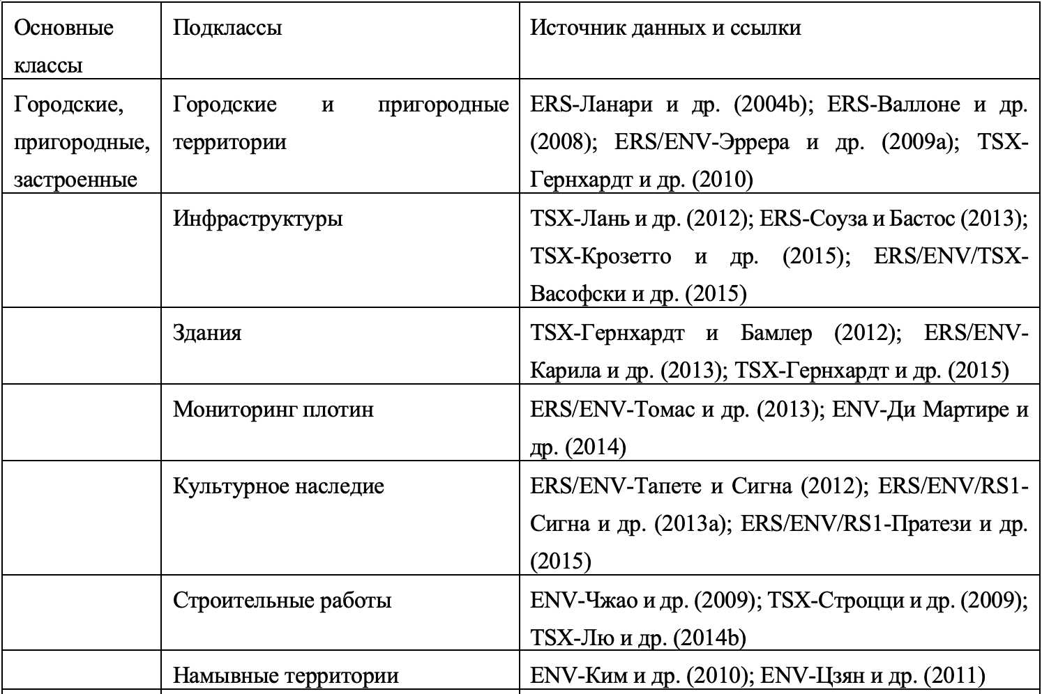
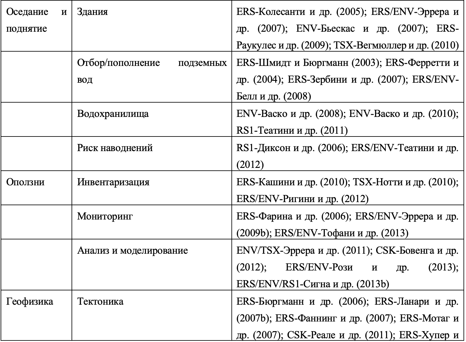
Таблица 2
Классификация наиболее важных приложений PSI с ссылками для каждого приложения.

Здесь рассматриваются некоторые из наиболее значимых работ по валидации PSI. Валидация, основанная на промежуточных продуктах различных цепочек PSI, выполненная в рамках Проекта валидации Terrafirma, описана в Адаме и др. (2009). Две работы описывают эксперименты с CR, проведённые в оптимальных условиях PSI: Маринкович и др. (2007) сообщают о σσ двойных разностей по вертикали 1.6 мм1.6мм и 2.6 мм2.6мм для данных Envisat и ERS соответственно, используя нивелирные данные, а Куин и Лоро (2013) сообщают о σσ временных рядов TerraSAR-X вдоль LOS 0.48 мм0.48мм с использованием микрометров. Несколько работ описывают результаты валидации скоростей деформации и временных рядов, в основном на основе нивелирных и GPS-данных. Массон и др. (2004) показывают сравнение скоростей деформации ERS со значениями, полученными по GPS, с разницами менее 0.5 мм/год0.5мм/год. Хупер и др. (2004) описывают результаты валидации в вулканическом приложении, где было достигнуто хорошее согласие в вертикальных движениях между PSI и топографическими данными. Колесанти и др. (2005) описывают валидацию, проведённую в горнодобывающем районе. Эта работа показывает ограничение PSI при быстрой и дециметровой деформации, происходящей во время обрушений (т.е. далёкой от идеальных условий PSI, упомянутых выше). Касу и др. (2006) описывают валидацию методики SBAS с данными ERS, получая σσ разностей скоростей 1 мм/год1мм/год и σσ 5 мм5мм для временных рядов деформации. Элено и др. (2011) описывают взаимное сравнение результатов двух независимых цепочек PSI и их валидацию с использованием нивелирных и GPS-данных. Наконец, Лю и др. (2014a) описывают валидацию результатов PSI TerraSAR-X, сообщая о σσ временных рядов деформации около 3 мм3мм. Особого упоминания заслуживает RTE, которая является ключевым параметром для геокодировки PS. В Проекте валидации Terrafirma, используя тот же подход взаимного сравнения, что и для скорости деформации, σσ RTE была оценена в диапазоне от 0.90.9 до 2.0 м2.0м. С учётом геометрии съёмки ERS и Envisat это даёт σσ геокодировки в диапазоне от 2.12.1 до 4.7 м4.7м. Эти значения отражают только прямой эффект разброса RTE, который примерно влияет на направление восток-запад (направление, перпендикулярное треку SAR). Две работы, посвящённые RTE, — это Периссин и Рокка (2006) и Периссин (2008).
5. Обзор основных приложений PSI
Потенциал метода PSI был признан с момента его первого предложения (Ферретти и др., 2001). За последние пятнадцать лет был разработан широкий спектр приложений PSI. Классификация наиболее важных приложений PSI приведена в Таблице 2, которая относится к четырём основным и частично перекрывающимся классам: (i) городские, пригородные и застроенные; (ii) оседание и поднятие; (iii) оползни; и (iv) геофизика. Каждый класс разделён на подклассы с указанием нескольких ссылок для каждого приложения.
Приложения PSI используют основные преимущества метода. Во-первых, PSI обеспечивает покрытие больших территорий с относительно высокой пространственной плотностью измерений. Это позволяет изучать обширные области (например, 100 на 100 км100км для одиночных кадров StripMap ERS и Envisat, 250 на 250 км250км для одиночных кадров широкополосного режима Interferometric Wide Swath Sentinel-1), получая глобальный обзор деформационных явлений на снимаемых территориях. В то же время PSI сохраняет способность измерять отдельные инфраструктуры, здания, деформационные явления малой площади и т.д. Эта способность особенно очевидна при использовании данных X-диапазона очень высокого разрешения. Фактически, доступность таких данных с 2007 года значительно увеличила потенциал применения PSI. Во-вторых, PSI обладает высокой чувствительностью к малым деформациям, что имеет фундаментальное значение для большинства приложений PSI. В-третьих, уникальной возможностью является способность измерять прошлые деформационные явления с использованием исторических архивов SAR-изображений. Этот уникальный аспект означает, что можно изучать деформационные явления, происходившие в прошлом и для которых нет других данных съёмки. Однако доступность изображений сильно варьируется от одной миссии к другой и крайне неравномерна по всему миру. В-четвёртых, PSI даёт возможность потенциального сокращения объёма наземных наблюдений, упрощения логистических операций и снижения затрат времени и персонала. Наконец, стоит отметить, что данные Sentinel-1 доступны бесплатно, что является дополнительным преимуществом для содействия разработке новых приложений PSI. Основной задачей для сообщества PSI является разработка новых инструментов для обработки и анализа огромного объёма данных, получаемых этим сенсором.
6. Заключение и перспективы
PSI — это метод дистанционного зондирования, позволяющий измерять миллиметровые смещения земной поверхности из космоса. Этот удивительный факт был широко продемонстрирован несколькими исследовательскими группами и коммерческими компаниями и задокументирован сотнями научных статей и публикаций высокого качества. С момента внедрения первой методики PSI (Ферретти и др., 2000, 2001) было проведено множество исследований и разработок. В данной статье описано около 20 различных подходов PSI, но их число, безусловно, больше и будет расти в будущем. Достигнутые к настоящему времени технические усовершенствования касаются всех основных компонентов PSI: (i) достижения в выборе пикселей для увеличения плотности и качества измерений PSI, например, распределённые рассеиватели, частично когерентные цели и т.д.; (ii) улучшение алгоритмов 2D и 3D развёртки фазы; (iii) использование более гибких и точных моделей деформации; (iv) улучшение алгоритмов оценки атмосферной фазовой компоненты; (v) способность создавать продукты деформации для обширных территорий; и т.д. Потенциал метода PSI можно выделить с двух точек зрения. Первая — это результаты валидации PSI, которые были рассмотрены в этой работе. Эти результаты полезны для оценки высокой чувствительности, точности и правильности продуктов PSI. Однако читатель предупреждается, что PSI — это довольно сложный процесс, и его эффективность зависит от множества факторов (SAR-сенсор, количество SAR-изображений, плотность PS, характеристики рассматриваемой деформации и т.д.). Вторая точка зрения — это широкий спектр приложений PSI, описанных в литературе и кратко рассмотренных в данной статье. Дополнительным и важным фактором успеха PSI является текущая доступность нескольких активных SAR-миссий и планы нескольких космических агентств по обеспечению преемственности этих миссий в будущем.
Основные открытые проблемы PSI и направления будущих исследований:
Несмотря на огромные усилия в области исследований и разработок за последние пятнадцать лет, безусловно, есть возможности для улучшения. Фактически, различные подходы PSI могут стать ещё более гибкими и надёжными. Одним из наиболее важных компонентов, требующих улучшения, является развёртка фазы: необходимы более гибкие и устойчивые методы, способные предупреждать пользователя, когда оценка фазовой неоднозначности, а следовательно, и оценка деформации, даёт сбой или может дать сбой. Различным подходам PSI часто не хватает полной характеристики качества их этапов обработки. В целом, существует потребность в полной характеристике неопределённости, связанной с основными компонентами обработки данных PSI и различных продуктов PSI. Важный вклад в этом направлении даёт геодезический подход, описанный в ван Лейене (2014). Различные подходы PSI имеют разную степень зрелости и производительности. Для правильного информирования потенциальных пользователей и повышения признания методики было бы полезно организовать новые упражнения по взаимному сравнению результатов, полученных с помощью различных подходов PSI, такие как проведённое в Проекте валидации Terrafirma. Возможности получения данных SAR-сенсорами значительно превышают пропускную способность всех доступных PSI-систем. Существует необходимость в увеличении вычислительной мощности текущих алгоритмов PSI. Это включает повышение степени их автоматизации, ускорение контроля качества различных этапов обработки PSI. Цель состоит в том, чтобы достичь возможности массовой обработки данных для систематического мониторинга очень обширных территорий. Параллельно с предыдущим пунктом существует необходимость в улучшении способности использовать результаты PSI. Фактически, добавленная стоимость PSI во многом зависит от интерпретации и использования её измерений деформации. Хотя это не всегда так, использование PSI часто находится в руках неспециалистов в области PSI, которые могут не знать, что некоторые особенности продуктов PSI не являются общими для других методов измерения деформации, например, оппортунистическая выборка PSI, ошибки развёртки фазы, остаточные тренды на картах скоростей и т.д. Чтобы повысить возможность использования PSI, необходимо должным образом документировать и сообщать характеристики и особенности продуктов PSI. Кроме того, желательно усилить сотрудничество между экспертами по PSI и лицами, ответственными за интерпретацию и использование результатов PSI. Эти два вида деятельности необходимы для повышения признания методики PSI в различных технических секторах, например, геоматике и, в частности, в сообществе мониторинга деформации, гражданском строительстве, геотехнике, инженерной геологии, геологии, управлении природными рисками и т.д.
5. Обзор основных приложений PSI
Потенциал метода PSI был признан с момента его первого предложения (Ферретти и др., 2001). За последние пятнадцать лет был разработан широкий спектр приложений PSI. Классификация наиболее важных приложений PSI приведена в Таблице 2, которая относится к четырём основным и частично перекрывающимся классам: (i) городские, пригородные и застроенные; (ii) оседание и поднятие; (iii) оползни; и (iv) геофизика. Каждый класс разделён на подклассы с указанием нескольких ссылок для каждого приложения.
Приложения PSI используют основные преимущества метода. Во-первых, PSI обеспечивает покрытие больших территорий с относительно высокой пространственной плотностью измерений. Это позволяет изучать обширные области (например, 100 на 100 км100км для одиночных кадров StripMap ERS и Envisat, 250 на 250 км250км для одиночных кадров широкополосного режима Interferometric Wide Swath Sentinel-1), получая глобальный обзор деформационных явлений на снимаемых территориях. В то же время PSI сохраняет способность измерять отдельные инфраструктуры, здания, деформационные явления малой площади и т.д. Эта способность особенно очевидна при использовании данных X-диапазона очень высокого разрешения. Фактически, доступность таких данных с 2007 года значительно увеличила потенциал применения PSI. Во-вторых, PSI обладает высокой чувствительностью к малым деформациям, что имеет фундаментальное значение для большинства приложений PSI. В-третьих, уникальной возможностью является способность измерять прошлые деформационные явления с использованием исторических архивов SAR-изображений. Этот уникальный аспект означает, что можно изучать деформационные явления, происходившие в прошлом и для которых нет других данных съёмки. Однако доступность изображений сильно варьируется от одной миссии к другой и крайне неравномерна по всему миру. В-четвёртых, PSI даёт возможность потенциального сокращения объёма наземных наблюдений, упрощения логистических операций и снижения затрат времени и персонала. Наконец, стоит отметить, что данные Sentinel-1 доступны бесплатно, что является дополнительным преимуществом для содействия разработке новых приложений PSI. Основной задачей для сообщества PSI является разработка новых инструментов для обработки и анализа огромного объёма данных, получаемых этим сенсором.
6. Заключение и перспективы
PSI — это метод дистанционного зондирования, позволяющий измерять миллиметровые смещения земной поверхности из космоса. Этот удивительный факт был широко продемонстрирован несколькими исследовательскими группами и коммерческими компаниями и задокументирован сотнями научных статей и публикаций высокого качества. С момента внедрения первой методики PSI (Ферретти и др., 2000, 2001) было проведено множество исследований и разработок. В данной статье описано около 20 различных подходов PSI, но их число, безусловно, больше и будет расти в будущем. Достигнутые к настоящему времени технические усовершенствования касаются всех основных компонентов PSI: (i) достижения в выборе пикселей для увеличения плотности и качества измерений PSI, например, распределённые рассеиватели, частично когерентные цели и т.д.; (ii) улучшение алгоритмов 2D и 3D развёртки фазы; (iii) использование более гибких и точных моделей деформации; (iv) улучшение алгоритмов оценки атмосферной фазовой компоненты; (v) способность создавать продукты деформации для обширных территорий; и т.д. Потенциал метода PSI можно выделить с двух точек зрения. Первая — это результаты валидации PSI, которые были рассмотрены в этой работе. Эти результаты полезны для оценки высокой чувствительности, точности и правильности продуктов PSI. Однако читатель предупреждается, что PSI — это довольно сложный процесс, и его эффективность зависит от множества факторов (SAR-сенсор, количество SAR-изображений, плотность PS, характеристики рассматриваемой деформации и т.д.). Вторая точка зрения — это широкий спектр приложений PSI, описанных в литературе и кратко рассмотренных в данной статье. Дополнительным и важным фактором успеха PSI является текущая доступность нескольких активных SAR-миссий и планы нескольких космических агентств по обеспечению преемственности этих миссий в будущем.
Основные открытые проблемы PSI и направления будущих исследований:
Несмотря на огромные усилия в области исследований и разработок за последние пятнадцать лет, безусловно, есть возможности для улучшения. Фактически, различные подходы PSI могут стать ещё более гибкими и надёжными. Одним из наиболее важных компонентов, требующих улучшения, является развёртка фазы: необходимы более гибкие и устойчивые методы, способные предупреждать пользователя, когда оценка фазовой неоднозначности, а следовательно, и оценка деформации, даёт сбой или может дать сбой. Различным подходам PSI часто не хватает полной характеристики качества их этапов обработки. В целом, существует потребность в полной характеристике неопределённости, связанной с основными компонентами обработки данных PSI и различных продуктов PSI. Важный вклад в этом направлении даёт геодезический подход, описанный в ван Лейене (2014). Различные подходы PSI имеют разную степень зрелости и производительности. Для правильного информирования потенциальных пользователей и повышения признания методики было бы полезно организовать новые упражнения по взаимному сравнению результатов, полученных с помощью различных подходов PSI, такие как проведённое в Проекте валидации Terrafirma. Возможности получения данных SAR-сенсорами значительно превышают пропускную способность всех доступных PSI-систем. Существует необходимость в увеличении вычислительной мощности текущих алгоритмов PSI. Это включает повышение степени их автоматизации, ускорение контроля качества различных этапов обработки PSI. Цель состоит в том, чтобы достичь возможности массовой обработки данных для систематического мониторинга очень обширных территорий. Параллельно с предыдущим пунктом существует необходимость в улучшении способности использовать результаты PSI. Фактически, добавленная стоимость PSI во многом зависит от интерпретации и использования её измерений деформации. Хотя это не всегда так, использование PSI часто находится в руках неспециалистов в области PSI, которые могут не знать, что некоторые особенности продуктов PSI не являются общими для других методов измерения деформации, например, оппортунистическая выборка PSI, ошибки развёртки фазы, остаточные тренды на картах скоростей и т.д. Чтобы повысить возможность использования PSI, необходимо должным образом документировать и сообщать характеристики и особенности продуктов PSI. Кроме того, желательно усилить сотрудничество между экспертами по PSI и лицами, ответственными за интерпретацию и использование результатов PSI. Эти два вида деятельности необходимы для повышения признания методики PSI в различных технических секторах, например, геоматике и, в частности, в сообществе мониторинга деформации, гражданском строительстве, геотехнике, инженерной геологии, геологии, управлении природными рисками и т.д.
Благодарность
Эта работа была частично профинансирована Министерством экономики и конкурентоспособности Испании в рамках проекта MIDES (Ref: CGL2013-43000-P).
Список литературы
Adam, N., Parizzi, A., Eineder, M., Crosetto, M., 2009. Practical persistent scatterer processing validation in the course of the Terrafirma project. J. Appl. Geophys. 69 (1), 59-65.
(Далее следует полный список литературы, как в оригинале, начиная с Adam и заканчивая Zhao et al. Я привожу его полностью, так как он является частью статьи. Поскольку он длинный, я включу его целиком.)
Adam, N., Parizzi, A., Eineder, M., Crosetto, M., 2009. Practical persistent scatterer processing validation in the course of the Terrafirma project. J. Appl. Geophys. 69 (1), 59-65.
Agram, P.S., Jolivet, R., Rau, C., Simons, M., 2013. InSAR time series analysis with ISCE. In: AGU Fall Meeting Abstracts, vol. 1, p. 1776.
Alshawaf, F., Fuhrmann, T., Knöpfler, A., Luo, X., Mayer, M., Hinz, S., 2015. Improving the accuracy of InSAR time series by the assimilation of atmospheric delay estimates from weather models. IEEE TGRS 53 (4), 1818-1832.
Amelung, F., Galloway, D.L., Bell, J.W., Zebker, H.A., Laczniak, R.J., 1999. Sensing the ups and downs of Las Vegas: InSAR reveals structural control of land subsidence and aquifer-system deformation. Geology 27 (6), 483-486.
Antonioli, A., Bignami, C., Manzo, M., Pepe, S., Zinno, I., Casu, F., Lanari, R., 2014. The 2011 Etna volcano eruption: a DInSAR perspective. In: EGU General Assembly Conference Abstracts, vol. 16, p. 13928.
Auer, S., Hinz, S., Bamler, R., 2010. Ray-tracing simulation techniques for understanding high-resolution SAR images. IEEE TGRS 48 (3), 1445-1456.
Auer, S., Gernhardt, S., Bamler, R., 2011. Persistent scatterer signatures in building shadows. In: Proceedings of IGARSS 2011, Vancouver, pp. 3665-3668.
Bamler, R., Hartl, P., 1998. Synthetic aperture radar interferometry. Inverse Probl. 14 (4), R1-R54.
Basilico, M., Ferretti, A., Novali, F., 2004. Permanent Scatterers: a temporal coherence approach. In: Proceedings of FRINGE 2003, Frascati, Italy.
Bateson, L., Cigna, F., Boon, D., Sowter, A., 2010. The application of the Intermittent SBAS (ISBAS) InSAR method to the South Wales Coalfield, UK. Int. J. Appl. Earth Obs. Geoinf. 12 (3), 153-161.
Bechor, N.B., Zebker, H.A., 2006. Measuring two-dimensional movements using a single InSAR pair. Geophys. Res. Lett. 33 (16).
Bell, J.W., Amelung, F., Ferretti, A., Novali, F., 2008. Permanent scatterer InSAR reveals seasonal and long-term aquifer-system response to groundwater pumping and artificial recharge. Water Resour. Res. 44 (2).
Berardino, P., Fornaro, G., Lanari, R., Sansosti, E., 2002. A new algorithm for surface deformation monitoring based on small baseline differential SAR interferograms. IEEE TGRS 40 (11), 2375-2383.
Biescas, E., Crosetto, M., Agudo, M., 2007. Two-dimensional deformation analysis using PSI. In: Proceedings of FRINGE 2007, Frascati, Italy.
Bovenga, F., Nitti, D.O., Refice, A., Nutricato, R., 2012. Using X-band SAR data for landslide monitoring: a case study. In: Proceedings of IGARSS 2012, Munich, pp. 2829-2832.
Bürgmann, R., Hilley, G., Ferretti, A., Novali, F., 2006. Resolving vertical tectonics in the San Francisco Bay Area from permanent scatterer InSAR and GPS analysis. Geology 34 (3), 221-224.
Carnec, C., Massonnet, D., King, C., 1996. Two examples of the use of SAR interferometry on displacement fields of small spatial extent. Geophys. Res. Lett. 23 (24), 3579-3582.
Caro Cuenca, M., Hanssen, R.F., Hooper, A., Arikan, M., 2011. Surface deformation of the whole Netherlands using PSI. In: Proceedings of FRINGE 2011, Frascati, Italy.
Cascini, L., Fornaro, G., Peduto, D., 2010. Advanced low- and high-resolution DInSAR map generation for slow-moving landslides. Eng. Geol. 116 (3), 207-222.
Casu, F., Manzo, M., Lanari, R., 2006. A quantitative assessment of the SBAS algorithm performance for surface deformation retrieval from DInSAR data. Remote Sens. Environ. 102 (3), 195-210.
Casu, F., Manunta, M., Zinno, I., Lanari, R., 2011. A new algorithm for the retrieval of 2D displacements from SAR data. In: Proceedings of IGARSS 2011, Vancouver, pp. 1537-1540.
Catalao, J., Nico, G., Pelich, R., 2011. Correction of atmospheric phase screen in PSI using GNSS data. In: Proceedings of FRINGE 2011, Frascati, Italy.
Chen, Y.A., Chang, C.P., Yen, J.Y., Hooper, A., 2010. Combining PSI and GPS for studying land deformation in Taiwan. In: EGU General Assembly Conference Abstracts, vol. 12, p. 10733.
Cigna, F., Tapete, D., Casagli, N., 2013a. The contribution of PSI to the analysis of cultural heritage: the case study of the city of Rome. In: Proceedings of IGARSS 2013, Melbourne, pp. 694-697.
Cigna, F., Bateson, L., Jordan, C., Dashwood, C., 2013b. Landslide mapping and monitoring in the UK using PSI: a case study from the North Yorkshire Moors. In: EGU General Assembly Conference Abstracts, vol. 15, p. 10199.
Colesanti, C., Wasowski, J., 2006. Investigating landslides with space-borne Synthetic Aperture Radar (SAR) interferometry. Eng. Geol. 88 (3), 173-199.
Colesanti, C., Ferretti, A., Prati, C., Rocca, F., 2003. Monitoring landslides and tectonic motions with the Permanent Scatterers technique. Eng. Geol. 68 (1), 3-14.
Colesanti, C., Mouelic, S.L., Bennett, V., Wasowski, J., 2005. Detecting mining-induced ground deformation with PSInSAR: a case study in the Apennines, Italy. In: Proceedings of FRINGE 2005, Frascati, Italy.
Costantini, M., Malvarosa, F., Minati, F., 2002. A new phase unwrapping method for SAR interferometry. In: Proceedings of IGARSS 2002, Toronto, pp. 1024-1026.
Costantini, M., Falco, S., Malvarosa, F., Minati, F., 2008. A new method for the identification and analysis of persistent scatterers. In: Proceedings of IGARSS 2008, Boston, pp. II-203.
Costantini, M., Malvarosa, F., Minati, F., 2012. Wide-area PSI processing: a case study over Europe. In: Proceedings of EUSAR 2012, Nuremberg, pp. 241-244.
Costantini, M., Minati, F., Malvarosa, F., 2014. A novel approach to PSI phase unwrapping. IEEE TGRS 52 (6), 3218-3227.
Crosetto, M., Crippa, B., Biescas, E., 2005. Early detection of deformation using PSI. In: Proceedings of FRINGE 2005, Frascati, Italy.
Crosetto, M., Biescas, E., Duro, J., Closa, J., Arnaud, A., 2008a. Generation of advanced ERS and Envisat interferometric SAR products using the Stable Point Network technique. Photogramm. Eng. Remote Sens. 74 (4), 443-450.
Crosetto, M., Monserrat, O., Luzi, G., Cuevas, M., 2008b. Validation of PSI time series. In: Proceedings of the 7th European Conference on Synthetic Aperture Radar (EUSAR), Friedrichshafen, pp. 1-4.
Crosetto, M., Monserrat, O., Luzi, G., Cuevas, M., 2009. Terrafirma validation project: validation of PSI results. In: Proceedings of FRINGE 2009, Frascati, Italy.
Crosetto, M., Monserrat, O., Luzi, G., Cuevas, M., 2010. Deformation monitoring using X-band PSI. In: Proceedings of IGARSS 2010, Honolulu, pp. 2767-2770.
Crosetto, M., Monserrat, O., Cuevas, M., 2013. DInSAR monitoring with corner reflectors. In: Proceedings of the 8th International Workshop on Advances in SAR Interferometry (FRINGE 2013), Frascati, Italy.
Crosetto, M., Monserrat, O., Cuevas-González, M., Devanthéry, N., 2015. Measuring thermal expansion using X-band PSI. In: Proceedings of IGARSS 2015, Milan, pp. 4181-4184.
Dalla Via, G., Crosetto, M., Crippa, B., 2012. Resolving earthquake-induced deformation using DInSAR: the 2009 L'Aquila earthquake. In: EGU General Assembly Conference Abstracts, vol. 14, p. 11744.
Daqing, G., Xia, Y., Kaufmann, H., 2011. Monitoring land subsidence using corner reflectors and PSI. In: Proceedings of FRINGE 2011, Frascati, Italy.
De Zan, F., Monti Guarnieri, A., 2006. TOPSAR: terrain observation by progressive scans. IEEE TGRS 44 (9), 2352-2360.
Devanthéry, N., Crosetto, M., Monserrat, O., Cuevas-González, M., 2014. A novel approach to PSI using Cousin PS. In: Proceedings of IGARSS 2014, Quebec, pp. 1364-1367.
Dheenathayalan, P., van Leijen, F., Hanssen, R.F., 2011. Characterization of persistent scatterers. In: Proceedings of IGARSS 2011, Vancouver, pp. 3424-3427.
Di Martire, D., Iglesias, R., Monells, D., Centolanza, G., Mallorquí, J.J., 2014. Dam monitoring using PSI: a case study in Spain. In: Proceedings of IGARSS 2014, Quebec, pp. 1376-1379.
Dixon, T.H., Amelung, F., Ferretti, A., Novali, F., 2006. Subsidence and flooding in New Orleans. Nature 441 (7093), 587-588.
Doerry, A.W., 2008. Reflectors for SAR performance testing. Sandia Report SAND2008-7747.
Duro, J., Closa, J., Biescas, E., Arnaud, A., 2003. High-resolution PSI processing using the Stable Point Network (SPN) technique. In: Proceedings of IGARSS 2003, Toulouse, pp. 401-403.
Eineder, M., Adam, N., Bamler, R., 2009. Spaceborne spotlight SAR interferometry. IEEE TGRS 47 (2), 558-569.
Farina, P., Colombo, D., Fumagalli, A., Marks, F., Moretti, S., 2006. Permanent Scatterers for landslide investigations: outcomes from the ESA-SLAM project. Eng. Geol. 88 (3), 200-217.
Ferretti, A., Prati, C., Rocca, F., 2000. Nonlinear subsidence rate estimation using permanent scatterers in differential SAR interferometry. IEEE TGRS 38 (5), 2202-2212.
Ferretti, A., Prati, C., Rocca, F., 2001. Permanent scatterers in SAR interferometry. IEEE TGRS 39 (1), 8-20.
Ferretti, A., Novali, F., Bürgmann, R., Hilley, G., 2004. InSAR permanent scatterer analysis reveals ups and downs in San Francisco Bay area. Eos, Trans. Am. Geophys. Union 85 (34), 317-324.
Ferretti, A., Prati, C., Rocca, F., 2005. Thermal expansion effects in PSI. In: Proceedings of FRINGE 2005, Frascati, Italy.
Ferretti, A., Savio, G., Barzaghi, R., Borghi, A., Musazzi, S., Novali, F., Prati, C., Rocca, F., 2007. Submillimeter accuracy of InSAR time series: experimental validation. IEEE TGRS 45 (5), 1142-1153.
Ferretti, A., Fumagalli, A., Novali, F., Prati, C., Rocca, F., Rucci, A., 2011. A new algorithm for processing interferometric data-stacks: SqueeSAR. IEEE TGRS 49 (9), 3460-3470.
Fialko, Y., Simons, M., Agnew, D., 2001. The complete (3-D) surface displacement field in the epicentral area of the 1999 Mw7.1 Hector Mine earthquake, California, from space geodetic observations. Geophys. Res. Lett. 28 (16), 3063-3066.
Fornaro, G., Paucuillo, A., Reale, D., 2011. A null-space method for the phase unwrapping of multitemporal SAR interferometric stacks. IEEE TGRS 49 (6), 2323-2334.
Fornaro, G., Reale, D., Verde, S., 2013. Bridge thermal dilation monitoring with millimeter sensitivity via multidimensional SAR imaging. IEEE Geosci. Remote Sens. Lett. 10, 677-681.
Fornaro, G., D'Agostino, N., Giuliani, R., Noviello, C., Reale, D., Verde, S., 2014. Assimilation of GPS-derived atmospheric propagation delay in DInSAR data processing. J. Select. Top. Appl. Earth Obs. Remote Sens. 8 (2), 784-799.
Funning, G.J., Burgmann, R., Ferretti, A., Novali, F., Fumagalli, A., 2007. Creep on the Rodgers Creek fault, northern San Francisco Bay area from a 10 year PS-InSAR dataset. Geophys. Res. Lett. 34 (19).
Gabriel, A.K., Goldstein, R.M., Zebker, H.A., 1989. Mapping small elevation changes over large areas: differential radar interferometry. J. Geophys. Res. 94 (B7), 9183-9191.
Galloway, D.L., Hudnut, K.W., Ingebrtsen, S.E., Phillips, S.P., Peltzer, G., Rogez, F., Rosen, P.A., 1998. Detection of aquifer system compaction and land subsidence using interferometric synthetic aperture radar, Antelope Valley, Mojave Desert, California. Water Resour. Res. 34 (10), 2573-2585.
Garcia-Davalillo, J.C., Herrera, G., Notti, D., Strozzi, T., Alvarez-Fernandez, I., 2014. DInSAR analysis of ALOS PALSAR images for the assessment of very slow landslides: the Tena Valley case study. Landslides 11 (2), 225-246.
Gernhardt, S., Adam, N., Eineder, M., Bamler, R., 2010. Potential of very high resolution SAR for persistent scatterer interferometry in urban areas. Ann. GIS 16 (2), 103-111.
Gernhardt, S., Bamler, R., 2012. Deformation monitoring of single buildings using meter-resolution SAR data in PSI. ISPRS J. 73, 68-79.
Gernhardt, S., Auer, S., Eder, K., 2015. Persistent scatterers at building facades - evaluation of appearance and localization accuracy. ISPRS J. 100, 92-105.
Ghiglia, D.C., Pritt, M.D., 1998. Two-dimensional Phase Unwrapping: Theory, Algorithms, and Software. Wiley, New York.
Goel, K., Adam, N., 2014. A distributed scatterer interferometry approach for precision monitoring of known surface deformation phenomena. IEEE TGRS 52 (9), 5454-5468.
Goldstein, R.M., Engelhardt, H., Kamb, B., Frolich, R.M., 1993. Satellite radar interferometry for monitoring ice sheet motion: application to an Antarctic ice stream. Science 262 (5139), 1525-1530.
Hanssen, R., 2001. Radar Interferometry. Kluwer Academic Publishers, Dordrecht, The Netherlands.
Hanssen, R.F., Caro Cuenca, M., Klees, R., van der Marel, H., 2012. Decadal vertical deformation of the Netherlands via the geodetic integration of gravimetry. GNSS, leveling and SAR interferometry. In: AGU Fall Meeting Abstracts.
Heleno, S.I., Oliveira, L.G., Henriques, M.J., Falcao, A.P., Lima, J.N., Cooksley, G., Ferretti, A., Fonseca, A.M., Lobo-Ferreira, J.P., Fonseca, J.F., 2011. Persistent scatterers interferometry detects and measures ground subsidence in Lisbon. Remote Sens. Environ. 115 (8), 2152-2167.
Herrera, G., Tomás, R., López-Sánchez, J.M., Delgado, J., Mallorqui, J.J., Duque, S., Mulas, J., 2007. Advanced DInSAR analysis on mining areas: La Union case study (Murcia, SE Spain). Eng. Geol. 90 (3), 148-159.
Herrera, G., Tomás, R., Lopez-Sanchez, J.M., Delgado, J., Vicente, F., Mulas, J., Cooksley, G., Sanchez, M., Duro, J., Arnaud, A., Blanco, P., Duque, S., Mallorqui, J. J., De la Vega-Panizo, R., Monserrat, O., 2009a. Validation and comparison of advanced differential interferometry techniques: Murcia metropolitan area case study. ISPRS J. 64, 501-512.
Herrera, G., Davalillo, J.C., Mulas, J., Cooksley, G., Monserrat, O., Pancioli, V., 2009b. Mapping and monitoring geomorphological processes in mountainous areas using PSI data: central Pyrenees case study. Nat. Hazards and Earth Syst. Sci. 9 (5), 1587-1598.
Herrera, G., Notti, D., García-Davalillo, J.C., Mora, O., Cooksley, G., Sánchez, M., Arnaud, A., Crosetto, M., 2011. Analysis with C- and X-band satellite SAR data of the Portalet landslide area. Landslides 8 (2), 195-206.
Hetland, E.A., Musé, P., Simons, M., Lin, Y.N., Agram, P.S., DiCaprio, C.J., 2012. Multiscale InSAR time series (MinTS) analysis of surface deformation. J. Geophys. Res.: Solid Earth (1978-2012) 117 (B2).
Hooper, A., Zebker, H., Segall, P., Kampes, B., 2004. A new method for measuring deformation on volcanoes and other natural terrains using InSAR persistent scatterers. Geophys. Res. Lett. 31 (23).
Hooper, A., Zebker, H.A., 2007. Phase unwrapping in three dimensions with application to InSAR time series. JOSA A 24 (9), 2737-2747.
Hooper, A., 2008. A multi-temporal InSAR method incorporating both persistent scatterer and small baseline approaches. Geophys. Res. Lett. 35 (16).
Hooper, A., Pedersen, R., Sigmundsson, F., 2009. Constraints on magma intrusion at Eyjafjallajokull and Katla volcanoes in Iceland, from time series SAR interferometry. In: The VOLUME Project- Volcanoes: Understanding Subsurface Mass Movement. University College, Dublin, pp. 3-24.
Hu, J., Li, Z.W., Ding, X.L., Zhu, J.J., Zhang, L., Sun, Q., 2014. Resolving three-dimensional surface displacements from InSAR measurements: a review. Earth Sci. Rev. 133, 1-17.
Hung, W.C., Hwang, C., Chen, Y.A., Chang, C.P., Yen, J.Y., Hooper, A., Yang, C.Y., 2011. Surface deformation from persistent scatterers SAR interferometry and fusion with leveling data: a case study over the Choushui River Alluvial Fan, Taiwan. Remote Sens. Environ. 115 (4), 957-967.
Jiang, L., Lin, H., Cheng, S., 2011. Monitoring and assessing reclamation settlement in coastal areas with advanced InSAR techniques: Macao city (China) case study. Int. J. Remote Sens. 32 (13), 3565-3588.
Joughin, I.R., Kwok, R., Fahnestock, M.A., 1998. Interferometric estimation of three-dimensional ice-flow using ascending and descending passes. IEEE TGRS 36 (1), 25-37.
Jung, J., Kim, D.J., Park, S.E., 2014. Correction of atmospheric phase screen in time series InSAR using WRF model for monitoring volcanic activities. IEEE TGRS 52 (5), 2678-2689.
Kampes, B.M., Hanssen, R.F., Perski, Z., 2003. Radar interferometry with public domain tools. In: Proceedings of FRINGE 2003, Frascati, Italy.
Kampes, B.M., Hanssen, R.F., 2004. Ambiguity resolution for permanent scatterer interferometry. IEEE TGRS 42, 2446-2453.
Kampes, B.M., 2006. Radar Interferometry: Persistent Scatterer Technique. Springer, Dordrecht, The Netherlands.
Karila, K., Karjalainen, M., Hyyppä, J., Koskinen, J., Saaranen, V., Rouhiainen, P., 2013. A comparison of precise leveling and persistent scatterer SAR interferometry for building subsidence rate measurement. ISPRS Int. J. Geo- Inform. 2 (3), 797-816.
Kim, S.W., Wdowinski, S., Dixon, T.H., Amelung, F., Kim, J.W., Won, J.S., 2010. Measurements and predictions of subsidence induced by soil consolidation using persistent scatterer InSAR and a hyperbolic model. Geophys. Res. Lett. 37 (5).
Lan, H., Li, L., Liu, H., Yang, Z., 2012. Complex urban infrastructure deformation monitoring using high resolution PSI. J. Sel. Top. Appl. Earth Obs. Remote Sens. 5 (2), 643-651.
Lanari, R., Mora, O., Manunta, M., Mallorqui, J.J., Berardino, P., Sansosti, E., 2004a. A small-baseline approach for investigating deformations on full-resolution differential SAR interferograms. IEEE TGRS 42 (7), 1377-1386.
Lanari, R., Zeni, G., Manunta, M., Guarino, S., Berardino, P., Sansosti, E., 2004b. An integrated SAR/GIS approach for investigating urban deformation phenomena: a case study of the city of Naples, Italy. Int. J. Remote Sens. 25 (14), 2855-2867.
Lanari, R., Casu, F., Manzo, M., Zeni, G., Berardino, P., Manunta, M., Pepe, A., 2007a. An overview of the small baseline subset algorithm: a DInSAR technique for surface deformation analysis. Pure Appl. Geophys. 164 (4), 637-661.
Lanari, R., Casu, F., Manzo, M., Lundgren, P., 2007b. Application of the SBAS-DInSAR technique to fault creep: a case study of the Hayward fault, California. Remote Sens. Environ. 109 (1), 20-28.
Leighton, M., 2010. GPS and PSI integration for monitoring urban land motion (PhD thesis). University of Nottingham.
Liu, S., 2012. Satellite radar interferometry: estimation of the atmospheric delay (PhD thesis). Delft University of Technology.
Liu, G., Jia, H., Nie, Y., Li, T., Zhang, R., Yu, B., Li, Z., 2014a. Detecting subsidence in coastal areas by ultrashort-baseline TCFInSAR on the time series of high-resolution TerraSAR-X images. IEEE TGRS 52 (4), 1911-1923.
Liu, D., Sowter, A., Niemeyer, W., 2014b. Process-related deformation monitoring by PSI using high resolution space-based SAR data: a case study in Düsseldorf, Germany. Nat. Hazards Earth Syst. Sci. Discuss. 2 (7), 4813-4830.
Lombardini, F., 2005. Differential tomography: a new framework for SAR interferometry. IEEE TGRS 43 (1), 37-44.
López-Quiroz, P., Doin, M.P., Tupin, F., Briole, P., Nicolas, J.M., 2009. Time series analysis of Mexico City subsidence constrained by radar interferometry. J. Appl. Geophys. 69 (1), 1-15.
Lundgren, P., Casu, F., Manzo, M., Pepe, A., Berardino, P., Sansosti, E., Lanari, R., 2004. Gravity and magma induced spreading of Mount Etna volcano revealed by satellite radar interferometry. Geophys. Res. Lett. 31 (4).
Lv, X., Yazici, B., Zeghal, M., Bennett, V., Abdoun, T., 2014. Joint-scatterer processing for time-series InSAR. IEEE TGRS 52 (11), 7205-7221.
Marinkovic, P., Ketelaar, G., van Leijen, F., Hanssen, R., 2007. InSAR quality control: analysis of five years of corner reflector time series. In: Proceedings of FRINGE 2007, Frascati, Italy.
Massonnet, D., Rossi, M., Carmona, C., Adragna, F., Peltzer, G., Feigl, K., Rabaute, T., 1993. The displacement field of the Landers earthquake mapped by radar interferometry. Nature 364 (6433), 138-142.
Massonnet, D., Briole, P., Arnaud, A., 1995. Deflation of Mount Etna monitored by spaceborne radar interferometry. Nature 375 (6532), 567-570.
Massonnet, D., Feigl, K.L., 1998. Radar interferometry and its application to changes in the Earth's surface. Rev. Geophys. 36 (4), 441-500.
Massonnet, D., Sigmundsson, F., 2000. Remote sensing of volcano deformation by radar interferometry. In: Mouginis-Mark, P.J., Crisp, J.A., Fink, J.H. (Eds.), Remote Sensing of Active Volcanism. AGU, pp. 207-221.
Monserrat, O., Crosetto, M., Luzi, G., 2011. Thermal expansion in PSI: modeling and estimation. In: Proceedings of IGARSS 2011, Vancouver, pp. 3428-3431.
Monserrat, O., Crosetto, M., Luzi, G., 2014. A review of ground-based SAR interferometry. ISPRS J. 93, 1-18.
Mora, O., Mallorqui, J.J., Broquetas, A., 2003. Linear and nonlinear terrain deformation maps from a reduced set of interferometric SAR images. IEEE TGRS 41 (10), 2243-2253.
Motagh, M., Djamour, Y., Walter, T.R., Wetzel, H.U., Zschau, J., Arabi, S., 2007. Land subsidence in Mashhad Valley, northeast Iran: results from InSAR, levelling and GPS. Geophys. J. Int. 168 (2), 518-526.
Musson, R.M.W., Booth, D.E., Haynes, M., 2004. A comparison of GPS and PSInSAR measurements of crustal deformation in the UK. In: Proceedings of FRINGE 2003, Frascati, Italy.
Navarro-Sanchez, V.D., Lopez-Sanchez, J.M., 2012. Improvement of persistent-scatterer interferometry performance by means of a polarimetric optimization. IEEE Geosci. Remote Sens. Letters 9 (4), 609–613.
Navarro-Sanchez, V.D., Lopez-Sanchez, J.M., Ferro-Famil, L., 2014. Polarimetric approaches for persistent scatterers interferometry. IEEE TGRS 52 (3), 1667–1676.
Navarro-Sanchez, V.D., Lopez-Sanchez, J.M., 2014. Spatial adaptive speckle filtering driven by temporal polarimetric statistics and its application to PSI. IEEE TGRS 52 (8), 4548–4557.
Notti, D., Davalillo, J.C., Herrera, G., Mora, O., 2010. Assessment of the performance of X-band satellite radar data for landslide mapping and monitoring: upper Tena Valley case study. Nat. Hazards Earth Syst. Sci. 10, 1865–1875.
Pepe, A., Lanari, R., 2006. On the extension of the minimum cost flow algorithm for phase unwrapping of multitemporal differential SAR interferograms. IEEE TGRS 44 (9), 2374–2383.
Peltzer, G., Rosen, P., 1995. Surface displacement of the 17 May 1993 Eureka Valley, California, earthquake observed by SAR interferometry. Science 268 (5215), 1333–1336.
Pepe, A., Euillades, L.D., Manunta, M., Lanari, R., 2011. New advances of the extended minimum cost flow phase unwrapping algorithm for SBAS-DInSAR analysis at full spatial resolution. IEEE TGRS 49 (10), 4062–4079.
Perissin, D., Rocca, F., 2006. High-accuracy urban DEM using permanent scatterers. IEEE TGRS 44 (11), 3338–3347.
Perissin, D., Ferretti, A., 2007. Urban-target recognition by means of repeated spaceborne SAR images. IEEE TGRS 45 (12), 4043–4058.
Perissin, D., 2008. Validation of the submetric accuracy of vertical positioning of PSs in C-band. IEEE TGRS 5 (3), 502–506.
Perissin, D., Wang, Z., Wang, T., 2011. The SARPROZ InSAR tool for urban subsidence/manmade structure stability monitoring in China. In: Proceedings of 34th International Symposium for Remote Sensing of the Environment (ISRSE), Sydney.
Perissin, D., Wang, T., 2012. Repeat-pass SAR interferometry with partially coherent targets. IEEE TGRS 50 (1), 271–280.
Pratesi, F., Tapete, D., Terenzi, G., Del Ventisette, C., Moretti, S., 2015. Structural assessment of case study historical and modern buildings in the florentine area based on a PSI-driven seismic and hydrogeological risk analysis. In: Engineering Geology for Society and Territory – Volume 8. Springer International Publishing, pp. 345–349.
Prats-Iraola, P., Scheiber, R., Marotti, L., Wollstadt, S., Reigber, A., 2012. TOPS interferometry with TerraSAR-X. IEEE TGRS 50 (8), 3179–3188.
Quin, G., Loreaux, P., 2013. Submillimeter accuracy of multipass corner reflector monitoring by PS technique. IEEE TGRS 51 (3), 1775–1783.
Raucoules, D., Bourgine, B., De Michele, M., Le Cozannet, G., Closset, L., Bremmer, C., Veldkamp, H., Tragheim, D., Bateson, L., Crosetto, M., Agudo, M., Engdahl, M., 2009. Validation and intercomparison of Persistent Scatterers Interferometry: PSIC4 project results. J. Appl. Geophys. 68 (3), 335–347.
Reale, D., Nitti, D.O., Peduto, D., Nutricato, R., Bovenga, F., Fornaro, G., 2011. Postseismic deformation monitoring with the COSMO/SKYMED constellation. IEEE Geosci. Remote Sens. Lett. 8 (4), 696–700.
Reigber, A., Moreira, A., 2000. First demonstration of airborne SAR tomography using multibaseline L-band data. IEEE TGRS 38 (5), 2142–2152.
Righini, G., Pancioli, V., Casagli, N., 2012. Updating landslide inventory maps using Persistent Scatterer Interferometry (PSI). Int. J. Remote Sens. 33 (7), 2068–2096.
Rignot, E.J., Gogineni, S.P., Krabill, W.B., Ekholm, S., 1997. North and northeast Greenland ice discharge from satellite radar interferometry. Science 276 (5314), 934–937.
Rocca, F., 2004. Diameters of the orbital tubes in long-term interferometric SAR surveys. IEEE Geosci. Remote Sens. Lett. 1 (3), 224–227.
Rosen, P.A., Hensley, S., Joughin, I.R., Li, F.K., Madsen, S.N., Rodriguez, E., Goldstein, R.M., 2000. Synthetic aperture radar interferometry. Proc. IEEE 88 (3), 333–382.
Rosen, P.A., Hensley, S., Peltzer, G., Simons, M., 2004. Updated repeat orbit interferometry package released. Eos, Trans. Am. Geophys. Union 85 (5), 47.
Rosen, P., Lavalle, M., Pi, X., Buckley, S., Szeliga, W., Zebker, H., Gurrola, E., 2011. Techniques and tools for estimating ionospheric effects in interferometric and polarimetric SAR data. In: Proceedings of IGARSS 2011, Vancouver, pp. 1501–1504.
Rosi, A., Vannocci, P., Tofani, V., Gigli, G., Casagli, N., 2013. Landslide characterization using satellite interferometry (PSI), geotechnical investigations and numerical modelling: the case study of Ricasoli Village (Italy). Int. J. Geosci. 4 (05), 904.
Rucci, A., Ferretti, A., Monti Guarnieri, A., Rocca, F., 2012. Sentinel 1 SAR interferometry applications: the outlook for sub millimeter measurements. Remote Sens. Environ. 120, 156–163.
Samieie-Esfahany, S., Hanssen, R., van Thienen-Visser, K., Muntendam-Bos, A., 2009. On the effect of horizontal deformation on InSAR subsidence estimates. In: Proceedings of FRINGE 2009, Frascati, Italy.
Samsonov, S., Tiampo, K., 2011. Polarization phase difference analysis for selection of persistent scatterers in SAR interferometry. IEEE Geosci. Remote Sens. Lett. 8 (2), 331–335.
Sandwell, D.T., Price, E.J., 1998. Phase gradient approach to stacking interferograms. J. Geophys. Res.: Solid Earth (1978–2012) 103 (B12), 30183–30204.
Sandwell, D., Mellors, R., Tong, X., Wei, M., Wessel, P., 2011. Open radar interferometry software for mapping surface deformation. Eos, Trans. Am. Geophys. Union 92 (28), 234.
Sarabandi, K., Chiu, T.C., 1996. Optimum corner reflectors for calibration of imaging radars. IEEE Trans. Antennas Propag. 44 (10), 1348–1361.
Schmidt, D.A., Bürgmann, R., 2003. Time-dependent land uplift and subsidence in the Santa Clara valley, California, from a large interferometric synthetic aperture radar data set. J. Geophys. Res.: Solid Earth (1978–2012) 108 (B9).
Sousa, J.J., Bastos, L., 2013. Multi-temporal SAR interferometry reveals acceleration of bridge sinking before collapse. Nat. Hazards Earth Syst. Sci. 13 (3), 659–667.
Strozzi, T., Luckman, A., Murray, T., Wegmüller, U., Werner, C.L., 2002. Glacier motion estimation using SAR offset-tracking procedures. IEEE TGRS 40 (11), 2384–2391.
Strozzi, T., Teatini, P., Tosi, L., 2009. TerraSAR-X reveals the impact of the mobile barrier works on Venice coastland stability. Remote Sens. Environ. 113 (12), 2682–2688.
Tapete, D., Cigna, F., 2012. Rapid mapping and deformation analysis over cultural heritage and rural sites based on Persistent Scatterer Interferometry. Int. J. Geophys. 2012, 19p.
Teatini, P., Castelletto, N., Ferronato, M., Gambolati, G., Janna, C., Cairo, E., Marzorati, D., Colombo, D., Ferretti, A., Bagliani, A., Bottazzi, F., 2011. Geomechanical response to seasonal gas storage in depleted reservoirs: A case study in the Po River basin, Italy. J. Geophys. Res.: Earth Surf. (2003–2012) 116 (F2).
Teatini, P., Tosi, L., Strozzi, T., Carbognin, L., Cecconi, G., Rosselli, R., Libardo, S., 2012. Resolving land subsidence within the Venice Lagoon by persistent scatterer SAR interferometry. Phys. Chem. Earth, Parts A/B/C 40, 72–79.
Tofani, V., Raspini, F., Catani, F., Casagli, N., 2013. Persistent Scatterer Interferometry (PSI) technique for landslide characterization and monitoring. Remote Sens. 5 (3), 1045–1065.
Tomás, R., Cano, M., García-Barba, J., Vicente, F., Herrera, G., Lopez-Sanchez, J.M., Mallorquí, J.J., 2013. Monitoring an earthfill dam using differential SAR interferometry: La Pedrera dam, Alicante, Spain. Eng. Geol. 157, 21–32.
Torres, R., Snoeij, P., Geudtner, D., Bibby, D., Davidson, M., Attema, E., Potin, P., Rommen, B., Floury, N., Brown, M., Navas Travera, I., Deghaye, P., Duesmann, B., Rosich, B., Miranda, N., Bruno, C., L’Abbate, M., Croci, R., Pietropaolo, A., Huchlerc, M., Rostan, F., 2012. GMES Sentinel-1 mission. Remote Sens. Environ. 120, 9–24.
Vallone, P., Giammarinaro, M.S., Crosetto, M., Agudo, M., Biescas, E., 2008. Ground motion phenomena in Caltanissetta (Italy) investigated by InSAR and geological data integration. Eng. Geol. 98 (3), 144–155.
van Leijen, F., Hanssen, R., 2007. Ground water management and its consequences in Delft, the Netherlands as observed by persistent scatterer interferometry. In: Proceedings of FRINGE 2007, Frascati (Italy).
van Leijen, F., 2014. Persistent Scatterer Interferometry based on geodetic estimation theory (Doctoral dissertation). TU Delft, Delft University of Technology.
Vasco, D.W., Ferretti, A., Novali, F., 2008. Reservoir monitoring and characterization using satellite geodetic data: interferometric synthetic aperture radar observations from the Krechba field, Algeria. Geophysics 73 (6), WA113–WA122.
Vasco, D.W., Rucci, A., Ferretti, A., Novali, F., Bissell, R.C., Ringrose, P.S., Mathieson, A.S., Wright, I.W., 2010. Satellite-based measurements of surface deformation reveal fluid flow associated with the geological storage of carbon dioxide. Geophys. Res. Lett. 37 (3).
Wasowski, J., Bovenga, F., Refice, A., Nitti, D., Nutricato, R., 2015. High resolution PSI for mapping ground deformations and infrastructure instability. Engineering Geology for Society and Territory, vol. 2. Springer International Publishing, pp. 399–403.
Wegmüller, U., Walter, D., Spreckels, V., Werner, C.L., 2010. Nonuniform ground motion monitoring with TerraSAR-X persistent scatterer interferometry. IEEE TGRS 48, 895–904.
Werner, C., Wegmüller, U., Strozzi, T., Wiesmann, A., 2003. Interferometric point target analysis for deformation mapping. In: Proceedings of IGARSS 2003, Toulouse, France.
Wright, T., Parsons, B., Fielding, E., 2001. Measurement of interseismic strain accumulation across the North Anatolian Fault by satellite radar interferometry. Geophys. Res. Lett. 28 (10), 2117–2120.
Xia, Y., Kaufmann, H., Guo, X., 2002. Differential SAR interferometry using corner reflectors. In: Proceedings IGARSS 2002, Toronto.
Yu, B., Liu, G., Li, Z., Zhang, R., Jia, H., Wang, X., Cai, G., 2013. Subsidence detection by TerraSAR-X interferometry on a network of natural persistent scatterers and artificial corner reflectors. Comput. Geosci. 58, 126–136.
Zhang, L., Ding, X., Lu, Z., 2011. Ground settlement monitoring based on temporarily coherent points between two SAR acquisitions. ISPRS J. Photogramm. Remote Sens. 66 (1), 146–152.
Zhang, R., Liu, G., Li, T., Huang, L., Yu, B., Chen, Q., Li, Z., 2014. An integrated model for extracting surface deformation components by PSI time series. IEEE TGRS 11 (2), 544–548.
Zebker, H.A., Rosen, P.A., Hensley, S., 1997. Atmospheric effects in interferometric synthetic aperture radar surface deformation and topographic maps. J. Geophys. Res.: Solid Earth (1978–2012) 102 (B4), 7547–7563.
Zerbini, S., Richter, B., Rocca, F., van Dam, T., Matonti, F., 2007. A combination of space and terrestrial geodetic techniques to monitor land subsidence: case study, the Southeastern Po Plain, Italy. J. Geophys. Res.: Solid Earth 112 (B5).
Zhao, Q., Lin, H., Jiang, L., Chen, F., Cheng, S., 2009. A study of ground deformation in the Guangzhou urban area with persistent scatterer interferometry. Sensors 9 (1), 503–518.
Эта работа была частично профинансирована Министерством экономики и конкурентоспособности Испании в рамках проекта MIDES (Ref: CGL2013-43000-P).
Список литературы
Adam, N., Parizzi, A., Eineder, M., Crosetto, M., 2009. Practical persistent scatterer processing validation in the course of the Terrafirma project. J. Appl. Geophys. 69 (1), 59-65.
(Далее следует полный список литературы, как в оригинале, начиная с Adam и заканчивая Zhao et al. Я привожу его полностью, так как он является частью статьи. Поскольку он длинный, я включу его целиком.)
Adam, N., Parizzi, A., Eineder, M., Crosetto, M., 2009. Practical persistent scatterer processing validation in the course of the Terrafirma project. J. Appl. Geophys. 69 (1), 59-65.
Agram, P.S., Jolivet, R., Rau, C., Simons, M., 2013. InSAR time series analysis with ISCE. In: AGU Fall Meeting Abstracts, vol. 1, p. 1776.
Alshawaf, F., Fuhrmann, T., Knöpfler, A., Luo, X., Mayer, M., Hinz, S., 2015. Improving the accuracy of InSAR time series by the assimilation of atmospheric delay estimates from weather models. IEEE TGRS 53 (4), 1818-1832.
Amelung, F., Galloway, D.L., Bell, J.W., Zebker, H.A., Laczniak, R.J., 1999. Sensing the ups and downs of Las Vegas: InSAR reveals structural control of land subsidence and aquifer-system deformation. Geology 27 (6), 483-486.
Antonioli, A., Bignami, C., Manzo, M., Pepe, S., Zinno, I., Casu, F., Lanari, R., 2014. The 2011 Etna volcano eruption: a DInSAR perspective. In: EGU General Assembly Conference Abstracts, vol. 16, p. 13928.
Auer, S., Hinz, S., Bamler, R., 2010. Ray-tracing simulation techniques for understanding high-resolution SAR images. IEEE TGRS 48 (3), 1445-1456.
Auer, S., Gernhardt, S., Bamler, R., 2011. Persistent scatterer signatures in building shadows. In: Proceedings of IGARSS 2011, Vancouver, pp. 3665-3668.
Bamler, R., Hartl, P., 1998. Synthetic aperture radar interferometry. Inverse Probl. 14 (4), R1-R54.
Basilico, M., Ferretti, A., Novali, F., 2004. Permanent Scatterers: a temporal coherence approach. In: Proceedings of FRINGE 2003, Frascati, Italy.
Bateson, L., Cigna, F., Boon, D., Sowter, A., 2010. The application of the Intermittent SBAS (ISBAS) InSAR method to the South Wales Coalfield, UK. Int. J. Appl. Earth Obs. Geoinf. 12 (3), 153-161.
Bechor, N.B., Zebker, H.A., 2006. Measuring two-dimensional movements using a single InSAR pair. Geophys. Res. Lett. 33 (16).
Bell, J.W., Amelung, F., Ferretti, A., Novali, F., 2008. Permanent scatterer InSAR reveals seasonal and long-term aquifer-system response to groundwater pumping and artificial recharge. Water Resour. Res. 44 (2).
Berardino, P., Fornaro, G., Lanari, R., Sansosti, E., 2002. A new algorithm for surface deformation monitoring based on small baseline differential SAR interferograms. IEEE TGRS 40 (11), 2375-2383.
Biescas, E., Crosetto, M., Agudo, M., 2007. Two-dimensional deformation analysis using PSI. In: Proceedings of FRINGE 2007, Frascati, Italy.
Bovenga, F., Nitti, D.O., Refice, A., Nutricato, R., 2012. Using X-band SAR data for landslide monitoring: a case study. In: Proceedings of IGARSS 2012, Munich, pp. 2829-2832.
Bürgmann, R., Hilley, G., Ferretti, A., Novali, F., 2006. Resolving vertical tectonics in the San Francisco Bay Area from permanent scatterer InSAR and GPS analysis. Geology 34 (3), 221-224.
Carnec, C., Massonnet, D., King, C., 1996. Two examples of the use of SAR interferometry on displacement fields of small spatial extent. Geophys. Res. Lett. 23 (24), 3579-3582.
Caro Cuenca, M., Hanssen, R.F., Hooper, A., Arikan, M., 2011. Surface deformation of the whole Netherlands using PSI. In: Proceedings of FRINGE 2011, Frascati, Italy.
Cascini, L., Fornaro, G., Peduto, D., 2010. Advanced low- and high-resolution DInSAR map generation for slow-moving landslides. Eng. Geol. 116 (3), 207-222.
Casu, F., Manzo, M., Lanari, R., 2006. A quantitative assessment of the SBAS algorithm performance for surface deformation retrieval from DInSAR data. Remote Sens. Environ. 102 (3), 195-210.
Casu, F., Manunta, M., Zinno, I., Lanari, R., 2011. A new algorithm for the retrieval of 2D displacements from SAR data. In: Proceedings of IGARSS 2011, Vancouver, pp. 1537-1540.
Catalao, J., Nico, G., Pelich, R., 2011. Correction of atmospheric phase screen in PSI using GNSS data. In: Proceedings of FRINGE 2011, Frascati, Italy.
Chen, Y.A., Chang, C.P., Yen, J.Y., Hooper, A., 2010. Combining PSI and GPS for studying land deformation in Taiwan. In: EGU General Assembly Conference Abstracts, vol. 12, p. 10733.
Cigna, F., Tapete, D., Casagli, N., 2013a. The contribution of PSI to the analysis of cultural heritage: the case study of the city of Rome. In: Proceedings of IGARSS 2013, Melbourne, pp. 694-697.
Cigna, F., Bateson, L., Jordan, C., Dashwood, C., 2013b. Landslide mapping and monitoring in the UK using PSI: a case study from the North Yorkshire Moors. In: EGU General Assembly Conference Abstracts, vol. 15, p. 10199.
Colesanti, C., Wasowski, J., 2006. Investigating landslides with space-borne Synthetic Aperture Radar (SAR) interferometry. Eng. Geol. 88 (3), 173-199.
Colesanti, C., Ferretti, A., Prati, C., Rocca, F., 2003. Monitoring landslides and tectonic motions with the Permanent Scatterers technique. Eng. Geol. 68 (1), 3-14.
Colesanti, C., Mouelic, S.L., Bennett, V., Wasowski, J., 2005. Detecting mining-induced ground deformation with PSInSAR: a case study in the Apennines, Italy. In: Proceedings of FRINGE 2005, Frascati, Italy.
Costantini, M., Malvarosa, F., Minati, F., 2002. A new phase unwrapping method for SAR interferometry. In: Proceedings of IGARSS 2002, Toronto, pp. 1024-1026.
Costantini, M., Falco, S., Malvarosa, F., Minati, F., 2008. A new method for the identification and analysis of persistent scatterers. In: Proceedings of IGARSS 2008, Boston, pp. II-203.
Costantini, M., Malvarosa, F., Minati, F., 2012. Wide-area PSI processing: a case study over Europe. In: Proceedings of EUSAR 2012, Nuremberg, pp. 241-244.
Costantini, M., Minati, F., Malvarosa, F., 2014. A novel approach to PSI phase unwrapping. IEEE TGRS 52 (6), 3218-3227.
Crosetto, M., Crippa, B., Biescas, E., 2005. Early detection of deformation using PSI. In: Proceedings of FRINGE 2005, Frascati, Italy.
Crosetto, M., Biescas, E., Duro, J., Closa, J., Arnaud, A., 2008a. Generation of advanced ERS and Envisat interferometric SAR products using the Stable Point Network technique. Photogramm. Eng. Remote Sens. 74 (4), 443-450.
Crosetto, M., Monserrat, O., Luzi, G., Cuevas, M., 2008b. Validation of PSI time series. In: Proceedings of the 7th European Conference on Synthetic Aperture Radar (EUSAR), Friedrichshafen, pp. 1-4.
Crosetto, M., Monserrat, O., Luzi, G., Cuevas, M., 2009. Terrafirma validation project: validation of PSI results. In: Proceedings of FRINGE 2009, Frascati, Italy.
Crosetto, M., Monserrat, O., Luzi, G., Cuevas, M., 2010. Deformation monitoring using X-band PSI. In: Proceedings of IGARSS 2010, Honolulu, pp. 2767-2770.
Crosetto, M., Monserrat, O., Cuevas, M., 2013. DInSAR monitoring with corner reflectors. In: Proceedings of the 8th International Workshop on Advances in SAR Interferometry (FRINGE 2013), Frascati, Italy.
Crosetto, M., Monserrat, O., Cuevas-González, M., Devanthéry, N., 2015. Measuring thermal expansion using X-band PSI. In: Proceedings of IGARSS 2015, Milan, pp. 4181-4184.
Dalla Via, G., Crosetto, M., Crippa, B., 2012. Resolving earthquake-induced deformation using DInSAR: the 2009 L'Aquila earthquake. In: EGU General Assembly Conference Abstracts, vol. 14, p. 11744.
Daqing, G., Xia, Y., Kaufmann, H., 2011. Monitoring land subsidence using corner reflectors and PSI. In: Proceedings of FRINGE 2011, Frascati, Italy.
De Zan, F., Monti Guarnieri, A., 2006. TOPSAR: terrain observation by progressive scans. IEEE TGRS 44 (9), 2352-2360.
Devanthéry, N., Crosetto, M., Monserrat, O., Cuevas-González, M., 2014. A novel approach to PSI using Cousin PS. In: Proceedings of IGARSS 2014, Quebec, pp. 1364-1367.
Dheenathayalan, P., van Leijen, F., Hanssen, R.F., 2011. Characterization of persistent scatterers. In: Proceedings of IGARSS 2011, Vancouver, pp. 3424-3427.
Di Martire, D., Iglesias, R., Monells, D., Centolanza, G., Mallorquí, J.J., 2014. Dam monitoring using PSI: a case study in Spain. In: Proceedings of IGARSS 2014, Quebec, pp. 1376-1379.
Dixon, T.H., Amelung, F., Ferretti, A., Novali, F., 2006. Subsidence and flooding in New Orleans. Nature 441 (7093), 587-588.
Doerry, A.W., 2008. Reflectors for SAR performance testing. Sandia Report SAND2008-7747.
Duro, J., Closa, J., Biescas, E., Arnaud, A., 2003. High-resolution PSI processing using the Stable Point Network (SPN) technique. In: Proceedings of IGARSS 2003, Toulouse, pp. 401-403.
Eineder, M., Adam, N., Bamler, R., 2009. Spaceborne spotlight SAR interferometry. IEEE TGRS 47 (2), 558-569.
Farina, P., Colombo, D., Fumagalli, A., Marks, F., Moretti, S., 2006. Permanent Scatterers for landslide investigations: outcomes from the ESA-SLAM project. Eng. Geol. 88 (3), 200-217.
Ferretti, A., Prati, C., Rocca, F., 2000. Nonlinear subsidence rate estimation using permanent scatterers in differential SAR interferometry. IEEE TGRS 38 (5), 2202-2212.
Ferretti, A., Prati, C., Rocca, F., 2001. Permanent scatterers in SAR interferometry. IEEE TGRS 39 (1), 8-20.
Ferretti, A., Novali, F., Bürgmann, R., Hilley, G., 2004. InSAR permanent scatterer analysis reveals ups and downs in San Francisco Bay area. Eos, Trans. Am. Geophys. Union 85 (34), 317-324.
Ferretti, A., Prati, C., Rocca, F., 2005. Thermal expansion effects in PSI. In: Proceedings of FRINGE 2005, Frascati, Italy.
Ferretti, A., Savio, G., Barzaghi, R., Borghi, A., Musazzi, S., Novali, F., Prati, C., Rocca, F., 2007. Submillimeter accuracy of InSAR time series: experimental validation. IEEE TGRS 45 (5), 1142-1153.
Ferretti, A., Fumagalli, A., Novali, F., Prati, C., Rocca, F., Rucci, A., 2011. A new algorithm for processing interferometric data-stacks: SqueeSAR. IEEE TGRS 49 (9), 3460-3470.
Fialko, Y., Simons, M., Agnew, D., 2001. The complete (3-D) surface displacement field in the epicentral area of the 1999 Mw7.1 Hector Mine earthquake, California, from space geodetic observations. Geophys. Res. Lett. 28 (16), 3063-3066.
Fornaro, G., Paucuillo, A., Reale, D., 2011. A null-space method for the phase unwrapping of multitemporal SAR interferometric stacks. IEEE TGRS 49 (6), 2323-2334.
Fornaro, G., Reale, D., Verde, S., 2013. Bridge thermal dilation monitoring with millimeter sensitivity via multidimensional SAR imaging. IEEE Geosci. Remote Sens. Lett. 10, 677-681.
Fornaro, G., D'Agostino, N., Giuliani, R., Noviello, C., Reale, D., Verde, S., 2014. Assimilation of GPS-derived atmospheric propagation delay in DInSAR data processing. J. Select. Top. Appl. Earth Obs. Remote Sens. 8 (2), 784-799.
Funning, G.J., Burgmann, R., Ferretti, A., Novali, F., Fumagalli, A., 2007. Creep on the Rodgers Creek fault, northern San Francisco Bay area from a 10 year PS-InSAR dataset. Geophys. Res. Lett. 34 (19).
Gabriel, A.K., Goldstein, R.M., Zebker, H.A., 1989. Mapping small elevation changes over large areas: differential radar interferometry. J. Geophys. Res. 94 (B7), 9183-9191.
Galloway, D.L., Hudnut, K.W., Ingebrtsen, S.E., Phillips, S.P., Peltzer, G., Rogez, F., Rosen, P.A., 1998. Detection of aquifer system compaction and land subsidence using interferometric synthetic aperture radar, Antelope Valley, Mojave Desert, California. Water Resour. Res. 34 (10), 2573-2585.
Garcia-Davalillo, J.C., Herrera, G., Notti, D., Strozzi, T., Alvarez-Fernandez, I., 2014. DInSAR analysis of ALOS PALSAR images for the assessment of very slow landslides: the Tena Valley case study. Landslides 11 (2), 225-246.
Gernhardt, S., Adam, N., Eineder, M., Bamler, R., 2010. Potential of very high resolution SAR for persistent scatterer interferometry in urban areas. Ann. GIS 16 (2), 103-111.
Gernhardt, S., Bamler, R., 2012. Deformation monitoring of single buildings using meter-resolution SAR data in PSI. ISPRS J. 73, 68-79.
Gernhardt, S., Auer, S., Eder, K., 2015. Persistent scatterers at building facades - evaluation of appearance and localization accuracy. ISPRS J. 100, 92-105.
Ghiglia, D.C., Pritt, M.D., 1998. Two-dimensional Phase Unwrapping: Theory, Algorithms, and Software. Wiley, New York.
Goel, K., Adam, N., 2014. A distributed scatterer interferometry approach for precision monitoring of known surface deformation phenomena. IEEE TGRS 52 (9), 5454-5468.
Goldstein, R.M., Engelhardt, H., Kamb, B., Frolich, R.M., 1993. Satellite radar interferometry for monitoring ice sheet motion: application to an Antarctic ice stream. Science 262 (5139), 1525-1530.
Hanssen, R., 2001. Radar Interferometry. Kluwer Academic Publishers, Dordrecht, The Netherlands.
Hanssen, R.F., Caro Cuenca, M., Klees, R., van der Marel, H., 2012. Decadal vertical deformation of the Netherlands via the geodetic integration of gravimetry. GNSS, leveling and SAR interferometry. In: AGU Fall Meeting Abstracts.
Heleno, S.I., Oliveira, L.G., Henriques, M.J., Falcao, A.P., Lima, J.N., Cooksley, G., Ferretti, A., Fonseca, A.M., Lobo-Ferreira, J.P., Fonseca, J.F., 2011. Persistent scatterers interferometry detects and measures ground subsidence in Lisbon. Remote Sens. Environ. 115 (8), 2152-2167.
Herrera, G., Tomás, R., López-Sánchez, J.M., Delgado, J., Mallorqui, J.J., Duque, S., Mulas, J., 2007. Advanced DInSAR analysis on mining areas: La Union case study (Murcia, SE Spain). Eng. Geol. 90 (3), 148-159.
Herrera, G., Tomás, R., Lopez-Sanchez, J.M., Delgado, J., Vicente, F., Mulas, J., Cooksley, G., Sanchez, M., Duro, J., Arnaud, A., Blanco, P., Duque, S., Mallorqui, J. J., De la Vega-Panizo, R., Monserrat, O., 2009a. Validation and comparison of advanced differential interferometry techniques: Murcia metropolitan area case study. ISPRS J. 64, 501-512.
Herrera, G., Davalillo, J.C., Mulas, J., Cooksley, G., Monserrat, O., Pancioli, V., 2009b. Mapping and monitoring geomorphological processes in mountainous areas using PSI data: central Pyrenees case study. Nat. Hazards and Earth Syst. Sci. 9 (5), 1587-1598.
Herrera, G., Notti, D., García-Davalillo, J.C., Mora, O., Cooksley, G., Sánchez, M., Arnaud, A., Crosetto, M., 2011. Analysis with C- and X-band satellite SAR data of the Portalet landslide area. Landslides 8 (2), 195-206.
Hetland, E.A., Musé, P., Simons, M., Lin, Y.N., Agram, P.S., DiCaprio, C.J., 2012. Multiscale InSAR time series (MinTS) analysis of surface deformation. J. Geophys. Res.: Solid Earth (1978-2012) 117 (B2).
Hooper, A., Zebker, H., Segall, P., Kampes, B., 2004. A new method for measuring deformation on volcanoes and other natural terrains using InSAR persistent scatterers. Geophys. Res. Lett. 31 (23).
Hooper, A., Zebker, H.A., 2007. Phase unwrapping in three dimensions with application to InSAR time series. JOSA A 24 (9), 2737-2747.
Hooper, A., 2008. A multi-temporal InSAR method incorporating both persistent scatterer and small baseline approaches. Geophys. Res. Lett. 35 (16).
Hooper, A., Pedersen, R., Sigmundsson, F., 2009. Constraints on magma intrusion at Eyjafjallajokull and Katla volcanoes in Iceland, from time series SAR interferometry. In: The VOLUME Project- Volcanoes: Understanding Subsurface Mass Movement. University College, Dublin, pp. 3-24.
Hu, J., Li, Z.W., Ding, X.L., Zhu, J.J., Zhang, L., Sun, Q., 2014. Resolving three-dimensional surface displacements from InSAR measurements: a review. Earth Sci. Rev. 133, 1-17.
Hung, W.C., Hwang, C., Chen, Y.A., Chang, C.P., Yen, J.Y., Hooper, A., Yang, C.Y., 2011. Surface deformation from persistent scatterers SAR interferometry and fusion with leveling data: a case study over the Choushui River Alluvial Fan, Taiwan. Remote Sens. Environ. 115 (4), 957-967.
Jiang, L., Lin, H., Cheng, S., 2011. Monitoring and assessing reclamation settlement in coastal areas with advanced InSAR techniques: Macao city (China) case study. Int. J. Remote Sens. 32 (13), 3565-3588.
Joughin, I.R., Kwok, R., Fahnestock, M.A., 1998. Interferometric estimation of three-dimensional ice-flow using ascending and descending passes. IEEE TGRS 36 (1), 25-37.
Jung, J., Kim, D.J., Park, S.E., 2014. Correction of atmospheric phase screen in time series InSAR using WRF model for monitoring volcanic activities. IEEE TGRS 52 (5), 2678-2689.
Kampes, B.M., Hanssen, R.F., Perski, Z., 2003. Radar interferometry with public domain tools. In: Proceedings of FRINGE 2003, Frascati, Italy.
Kampes, B.M., Hanssen, R.F., 2004. Ambiguity resolution for permanent scatterer interferometry. IEEE TGRS 42, 2446-2453.
Kampes, B.M., 2006. Radar Interferometry: Persistent Scatterer Technique. Springer, Dordrecht, The Netherlands.
Karila, K., Karjalainen, M., Hyyppä, J., Koskinen, J., Saaranen, V., Rouhiainen, P., 2013. A comparison of precise leveling and persistent scatterer SAR interferometry for building subsidence rate measurement. ISPRS Int. J. Geo- Inform. 2 (3), 797-816.
Kim, S.W., Wdowinski, S., Dixon, T.H., Amelung, F., Kim, J.W., Won, J.S., 2010. Measurements and predictions of subsidence induced by soil consolidation using persistent scatterer InSAR and a hyperbolic model. Geophys. Res. Lett. 37 (5).
Lan, H., Li, L., Liu, H., Yang, Z., 2012. Complex urban infrastructure deformation monitoring using high resolution PSI. J. Sel. Top. Appl. Earth Obs. Remote Sens. 5 (2), 643-651.
Lanari, R., Mora, O., Manunta, M., Mallorqui, J.J., Berardino, P., Sansosti, E., 2004a. A small-baseline approach for investigating deformations on full-resolution differential SAR interferograms. IEEE TGRS 42 (7), 1377-1386.
Lanari, R., Zeni, G., Manunta, M., Guarino, S., Berardino, P., Sansosti, E., 2004b. An integrated SAR/GIS approach for investigating urban deformation phenomena: a case study of the city of Naples, Italy. Int. J. Remote Sens. 25 (14), 2855-2867.
Lanari, R., Casu, F., Manzo, M., Zeni, G., Berardino, P., Manunta, M., Pepe, A., 2007a. An overview of the small baseline subset algorithm: a DInSAR technique for surface deformation analysis. Pure Appl. Geophys. 164 (4), 637-661.
Lanari, R., Casu, F., Manzo, M., Lundgren, P., 2007b. Application of the SBAS-DInSAR technique to fault creep: a case study of the Hayward fault, California. Remote Sens. Environ. 109 (1), 20-28.
Leighton, M., 2010. GPS and PSI integration for monitoring urban land motion (PhD thesis). University of Nottingham.
Liu, S., 2012. Satellite radar interferometry: estimation of the atmospheric delay (PhD thesis). Delft University of Technology.
Liu, G., Jia, H., Nie, Y., Li, T., Zhang, R., Yu, B., Li, Z., 2014a. Detecting subsidence in coastal areas by ultrashort-baseline TCFInSAR on the time series of high-resolution TerraSAR-X images. IEEE TGRS 52 (4), 1911-1923.
Liu, D., Sowter, A., Niemeyer, W., 2014b. Process-related deformation monitoring by PSI using high resolution space-based SAR data: a case study in Düsseldorf, Germany. Nat. Hazards Earth Syst. Sci. Discuss. 2 (7), 4813-4830.
Lombardini, F., 2005. Differential tomography: a new framework for SAR interferometry. IEEE TGRS 43 (1), 37-44.
López-Quiroz, P., Doin, M.P., Tupin, F., Briole, P., Nicolas, J.M., 2009. Time series analysis of Mexico City subsidence constrained by radar interferometry. J. Appl. Geophys. 69 (1), 1-15.
Lundgren, P., Casu, F., Manzo, M., Pepe, A., Berardino, P., Sansosti, E., Lanari, R., 2004. Gravity and magma induced spreading of Mount Etna volcano revealed by satellite radar interferometry. Geophys. Res. Lett. 31 (4).
Lv, X., Yazici, B., Zeghal, M., Bennett, V., Abdoun, T., 2014. Joint-scatterer processing for time-series InSAR. IEEE TGRS 52 (11), 7205-7221.
Marinkovic, P., Ketelaar, G., van Leijen, F., Hanssen, R., 2007. InSAR quality control: analysis of five years of corner reflector time series. In: Proceedings of FRINGE 2007, Frascati, Italy.
Massonnet, D., Rossi, M., Carmona, C., Adragna, F., Peltzer, G., Feigl, K., Rabaute, T., 1993. The displacement field of the Landers earthquake mapped by radar interferometry. Nature 364 (6433), 138-142.
Massonnet, D., Briole, P., Arnaud, A., 1995. Deflation of Mount Etna monitored by spaceborne radar interferometry. Nature 375 (6532), 567-570.
Massonnet, D., Feigl, K.L., 1998. Radar interferometry and its application to changes in the Earth's surface. Rev. Geophys. 36 (4), 441-500.
Massonnet, D., Sigmundsson, F., 2000. Remote sensing of volcano deformation by radar interferometry. In: Mouginis-Mark, P.J., Crisp, J.A., Fink, J.H. (Eds.), Remote Sensing of Active Volcanism. AGU, pp. 207-221.
Monserrat, O., Crosetto, M., Luzi, G., 2011. Thermal expansion in PSI: modeling and estimation. In: Proceedings of IGARSS 2011, Vancouver, pp. 3428-3431.
Monserrat, O., Crosetto, M., Luzi, G., 2014. A review of ground-based SAR interferometry. ISPRS J. 93, 1-18.
Mora, O., Mallorqui, J.J., Broquetas, A., 2003. Linear and nonlinear terrain deformation maps from a reduced set of interferometric SAR images. IEEE TGRS 41 (10), 2243-2253.
Motagh, M., Djamour, Y., Walter, T.R., Wetzel, H.U., Zschau, J., Arabi, S., 2007. Land subsidence in Mashhad Valley, northeast Iran: results from InSAR, levelling and GPS. Geophys. J. Int. 168 (2), 518-526.
Musson, R.M.W., Booth, D.E., Haynes, M., 2004. A comparison of GPS and PSInSAR measurements of crustal deformation in the UK. In: Proceedings of FRINGE 2003, Frascati, Italy.
Navarro-Sanchez, V.D., Lopez-Sanchez, J.M., 2012. Improvement of persistent-scatterer interferometry performance by means of a polarimetric optimization. IEEE Geosci. Remote Sens. Letters 9 (4), 609–613.
Navarro-Sanchez, V.D., Lopez-Sanchez, J.M., Ferro-Famil, L., 2014. Polarimetric approaches for persistent scatterers interferometry. IEEE TGRS 52 (3), 1667–1676.
Navarro-Sanchez, V.D., Lopez-Sanchez, J.M., 2014. Spatial adaptive speckle filtering driven by temporal polarimetric statistics and its application to PSI. IEEE TGRS 52 (8), 4548–4557.
Notti, D., Davalillo, J.C., Herrera, G., Mora, O., 2010. Assessment of the performance of X-band satellite radar data for landslide mapping and monitoring: upper Tena Valley case study. Nat. Hazards Earth Syst. Sci. 10, 1865–1875.
Pepe, A., Lanari, R., 2006. On the extension of the minimum cost flow algorithm for phase unwrapping of multitemporal differential SAR interferograms. IEEE TGRS 44 (9), 2374–2383.
Peltzer, G., Rosen, P., 1995. Surface displacement of the 17 May 1993 Eureka Valley, California, earthquake observed by SAR interferometry. Science 268 (5215), 1333–1336.
Pepe, A., Euillades, L.D., Manunta, M., Lanari, R., 2011. New advances of the extended minimum cost flow phase unwrapping algorithm for SBAS-DInSAR analysis at full spatial resolution. IEEE TGRS 49 (10), 4062–4079.
Perissin, D., Rocca, F., 2006. High-accuracy urban DEM using permanent scatterers. IEEE TGRS 44 (11), 3338–3347.
Perissin, D., Ferretti, A., 2007. Urban-target recognition by means of repeated spaceborne SAR images. IEEE TGRS 45 (12), 4043–4058.
Perissin, D., 2008. Validation of the submetric accuracy of vertical positioning of PSs in C-band. IEEE TGRS 5 (3), 502–506.
Perissin, D., Wang, Z., Wang, T., 2011. The SARPROZ InSAR tool for urban subsidence/manmade structure stability monitoring in China. In: Proceedings of 34th International Symposium for Remote Sensing of the Environment (ISRSE), Sydney.
Perissin, D., Wang, T., 2012. Repeat-pass SAR interferometry with partially coherent targets. IEEE TGRS 50 (1), 271–280.
Pratesi, F., Tapete, D., Terenzi, G., Del Ventisette, C., Moretti, S., 2015. Structural assessment of case study historical and modern buildings in the florentine area based on a PSI-driven seismic and hydrogeological risk analysis. In: Engineering Geology for Society and Territory – Volume 8. Springer International Publishing, pp. 345–349.
Prats-Iraola, P., Scheiber, R., Marotti, L., Wollstadt, S., Reigber, A., 2012. TOPS interferometry with TerraSAR-X. IEEE TGRS 50 (8), 3179–3188.
Quin, G., Loreaux, P., 2013. Submillimeter accuracy of multipass corner reflector monitoring by PS technique. IEEE TGRS 51 (3), 1775–1783.
Raucoules, D., Bourgine, B., De Michele, M., Le Cozannet, G., Closset, L., Bremmer, C., Veldkamp, H., Tragheim, D., Bateson, L., Crosetto, M., Agudo, M., Engdahl, M., 2009. Validation and intercomparison of Persistent Scatterers Interferometry: PSIC4 project results. J. Appl. Geophys. 68 (3), 335–347.
Reale, D., Nitti, D.O., Peduto, D., Nutricato, R., Bovenga, F., Fornaro, G., 2011. Postseismic deformation monitoring with the COSMO/SKYMED constellation. IEEE Geosci. Remote Sens. Lett. 8 (4), 696–700.
Reigber, A., Moreira, A., 2000. First demonstration of airborne SAR tomography using multibaseline L-band data. IEEE TGRS 38 (5), 2142–2152.
Righini, G., Pancioli, V., Casagli, N., 2012. Updating landslide inventory maps using Persistent Scatterer Interferometry (PSI). Int. J. Remote Sens. 33 (7), 2068–2096.
Rignot, E.J., Gogineni, S.P., Krabill, W.B., Ekholm, S., 1997. North and northeast Greenland ice discharge from satellite radar interferometry. Science 276 (5314), 934–937.
Rocca, F., 2004. Diameters of the orbital tubes in long-term interferometric SAR surveys. IEEE Geosci. Remote Sens. Lett. 1 (3), 224–227.
Rosen, P.A., Hensley, S., Joughin, I.R., Li, F.K., Madsen, S.N., Rodriguez, E., Goldstein, R.M., 2000. Synthetic aperture radar interferometry. Proc. IEEE 88 (3), 333–382.
Rosen, P.A., Hensley, S., Peltzer, G., Simons, M., 2004. Updated repeat orbit interferometry package released. Eos, Trans. Am. Geophys. Union 85 (5), 47.
Rosen, P., Lavalle, M., Pi, X., Buckley, S., Szeliga, W., Zebker, H., Gurrola, E., 2011. Techniques and tools for estimating ionospheric effects in interferometric and polarimetric SAR data. In: Proceedings of IGARSS 2011, Vancouver, pp. 1501–1504.
Rosi, A., Vannocci, P., Tofani, V., Gigli, G., Casagli, N., 2013. Landslide characterization using satellite interferometry (PSI), geotechnical investigations and numerical modelling: the case study of Ricasoli Village (Italy). Int. J. Geosci. 4 (05), 904.
Rucci, A., Ferretti, A., Monti Guarnieri, A., Rocca, F., 2012. Sentinel 1 SAR interferometry applications: the outlook for sub millimeter measurements. Remote Sens. Environ. 120, 156–163.
Samieie-Esfahany, S., Hanssen, R., van Thienen-Visser, K., Muntendam-Bos, A., 2009. On the effect of horizontal deformation on InSAR subsidence estimates. In: Proceedings of FRINGE 2009, Frascati, Italy.
Samsonov, S., Tiampo, K., 2011. Polarization phase difference analysis for selection of persistent scatterers in SAR interferometry. IEEE Geosci. Remote Sens. Lett. 8 (2), 331–335.
Sandwell, D.T., Price, E.J., 1998. Phase gradient approach to stacking interferograms. J. Geophys. Res.: Solid Earth (1978–2012) 103 (B12), 30183–30204.
Sandwell, D., Mellors, R., Tong, X., Wei, M., Wessel, P., 2011. Open radar interferometry software for mapping surface deformation. Eos, Trans. Am. Geophys. Union 92 (28), 234.
Sarabandi, K., Chiu, T.C., 1996. Optimum corner reflectors for calibration of imaging radars. IEEE Trans. Antennas Propag. 44 (10), 1348–1361.
Schmidt, D.A., Bürgmann, R., 2003. Time-dependent land uplift and subsidence in the Santa Clara valley, California, from a large interferometric synthetic aperture radar data set. J. Geophys. Res.: Solid Earth (1978–2012) 108 (B9).
Sousa, J.J., Bastos, L., 2013. Multi-temporal SAR interferometry reveals acceleration of bridge sinking before collapse. Nat. Hazards Earth Syst. Sci. 13 (3), 659–667.
Strozzi, T., Luckman, A., Murray, T., Wegmüller, U., Werner, C.L., 2002. Glacier motion estimation using SAR offset-tracking procedures. IEEE TGRS 40 (11), 2384–2391.
Strozzi, T., Teatini, P., Tosi, L., 2009. TerraSAR-X reveals the impact of the mobile barrier works on Venice coastland stability. Remote Sens. Environ. 113 (12), 2682–2688.
Tapete, D., Cigna, F., 2012. Rapid mapping and deformation analysis over cultural heritage and rural sites based on Persistent Scatterer Interferometry. Int. J. Geophys. 2012, 19p.
Teatini, P., Castelletto, N., Ferronato, M., Gambolati, G., Janna, C., Cairo, E., Marzorati, D., Colombo, D., Ferretti, A., Bagliani, A., Bottazzi, F., 2011. Geomechanical response to seasonal gas storage in depleted reservoirs: A case study in the Po River basin, Italy. J. Geophys. Res.: Earth Surf. (2003–2012) 116 (F2).
Teatini, P., Tosi, L., Strozzi, T., Carbognin, L., Cecconi, G., Rosselli, R., Libardo, S., 2012. Resolving land subsidence within the Venice Lagoon by persistent scatterer SAR interferometry. Phys. Chem. Earth, Parts A/B/C 40, 72–79.
Tofani, V., Raspini, F., Catani, F., Casagli, N., 2013. Persistent Scatterer Interferometry (PSI) technique for landslide characterization and monitoring. Remote Sens. 5 (3), 1045–1065.
Tomás, R., Cano, M., García-Barba, J., Vicente, F., Herrera, G., Lopez-Sanchez, J.M., Mallorquí, J.J., 2013. Monitoring an earthfill dam using differential SAR interferometry: La Pedrera dam, Alicante, Spain. Eng. Geol. 157, 21–32.
Torres, R., Snoeij, P., Geudtner, D., Bibby, D., Davidson, M., Attema, E., Potin, P., Rommen, B., Floury, N., Brown, M., Navas Travera, I., Deghaye, P., Duesmann, B., Rosich, B., Miranda, N., Bruno, C., L’Abbate, M., Croci, R., Pietropaolo, A., Huchlerc, M., Rostan, F., 2012. GMES Sentinel-1 mission. Remote Sens. Environ. 120, 9–24.
Vallone, P., Giammarinaro, M.S., Crosetto, M., Agudo, M., Biescas, E., 2008. Ground motion phenomena in Caltanissetta (Italy) investigated by InSAR and geological data integration. Eng. Geol. 98 (3), 144–155.
van Leijen, F., Hanssen, R., 2007. Ground water management and its consequences in Delft, the Netherlands as observed by persistent scatterer interferometry. In: Proceedings of FRINGE 2007, Frascati (Italy).
van Leijen, F., 2014. Persistent Scatterer Interferometry based on geodetic estimation theory (Doctoral dissertation). TU Delft, Delft University of Technology.
Vasco, D.W., Ferretti, A., Novali, F., 2008. Reservoir monitoring and characterization using satellite geodetic data: interferometric synthetic aperture radar observations from the Krechba field, Algeria. Geophysics 73 (6), WA113–WA122.
Vasco, D.W., Rucci, A., Ferretti, A., Novali, F., Bissell, R.C., Ringrose, P.S., Mathieson, A.S., Wright, I.W., 2010. Satellite-based measurements of surface deformation reveal fluid flow associated with the geological storage of carbon dioxide. Geophys. Res. Lett. 37 (3).
Wasowski, J., Bovenga, F., Refice, A., Nitti, D., Nutricato, R., 2015. High resolution PSI for mapping ground deformations and infrastructure instability. Engineering Geology for Society and Territory, vol. 2. Springer International Publishing, pp. 399–403.
Wegmüller, U., Walter, D., Spreckels, V., Werner, C.L., 2010. Nonuniform ground motion monitoring with TerraSAR-X persistent scatterer interferometry. IEEE TGRS 48, 895–904.
Werner, C., Wegmüller, U., Strozzi, T., Wiesmann, A., 2003. Interferometric point target analysis for deformation mapping. In: Proceedings of IGARSS 2003, Toulouse, France.
Wright, T., Parsons, B., Fielding, E., 2001. Measurement of interseismic strain accumulation across the North Anatolian Fault by satellite radar interferometry. Geophys. Res. Lett. 28 (10), 2117–2120.
Xia, Y., Kaufmann, H., Guo, X., 2002. Differential SAR interferometry using corner reflectors. In: Proceedings IGARSS 2002, Toronto.
Yu, B., Liu, G., Li, Z., Zhang, R., Jia, H., Wang, X., Cai, G., 2013. Subsidence detection by TerraSAR-X interferometry on a network of natural persistent scatterers and artificial corner reflectors. Comput. Geosci. 58, 126–136.
Zhang, L., Ding, X., Lu, Z., 2011. Ground settlement monitoring based on temporarily coherent points between two SAR acquisitions. ISPRS J. Photogramm. Remote Sens. 66 (1), 146–152.
Zhang, R., Liu, G., Li, T., Huang, L., Yu, B., Chen, Q., Li, Z., 2014. An integrated model for extracting surface deformation components by PSI time series. IEEE TGRS 11 (2), 544–548.
Zebker, H.A., Rosen, P.A., Hensley, S., 1997. Atmospheric effects in interferometric synthetic aperture radar surface deformation and topographic maps. J. Geophys. Res.: Solid Earth (1978–2012) 102 (B4), 7547–7563.
Zerbini, S., Richter, B., Rocca, F., van Dam, T., Matonti, F., 2007. A combination of space and terrestrial geodetic techniques to monitor land subsidence: case study, the Southeastern Po Plain, Italy. J. Geophys. Res.: Solid Earth 112 (B5).
Zhao, Q., Lin, H., Jiang, L., Chen, F., Cheng, S., 2009. A study of ground deformation in the Guangzhou urban area with persistent scatterer interferometry. Sensors 9 (1), 503–518.
08 сентября / 2026